Exploring Haram al-Sharif (Temple Mount): A Visitor's Guide
The Jews believe this is where the world was created and where it will finally end. The Muslims believe it was from here that the Prophet Muhammad ascended to heaven on the Mi'raj. Christians, Jews, and Muslims all believe that the Prophet Abraham stood here ready to sacrifice his son to prove himself to God. Initially the site of the Israelites' First and Second Temples and now home to the Dome of The Rock, the Haram al-Sharif is a place of deep faith and religious significance. It has been fought over down through the centuries and today, remains one of the most contentious plots of land on earth as well as one of the most recognisable landmarks in the world.
The Enclosure Walls
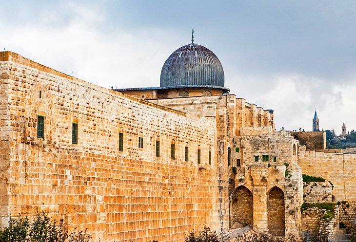
The walls enclosing the Haram al-Sharif reach their highest point (65 m) at the southeast corner, where there is a clear view of the massive blocks of dressed stone of the Herodian walls and the overlying courses of smaller stones of later restorations. There are seven gates leading up to the mount with the five most important being Bab al-Magharibeh (the only gate non-Muslims can enter through, though you can leave by any of them), Chain Gate (Bab es-Silsileh), the Cotton-Merchants' Gate (Bab el-Qattanin) with its stalactitic corbelling, the Iron Gate (Bab el-Hadid), and the Watchman's Gate (Bab en-Nazir). On the western and northern walls are four minaretswith a range of construction dates: at the southwest corner (1278, altered 1622), above Bab es-Silsileh (1329), at the northwest corner (1297), and - the youngest of the four - on the north wall (1937).
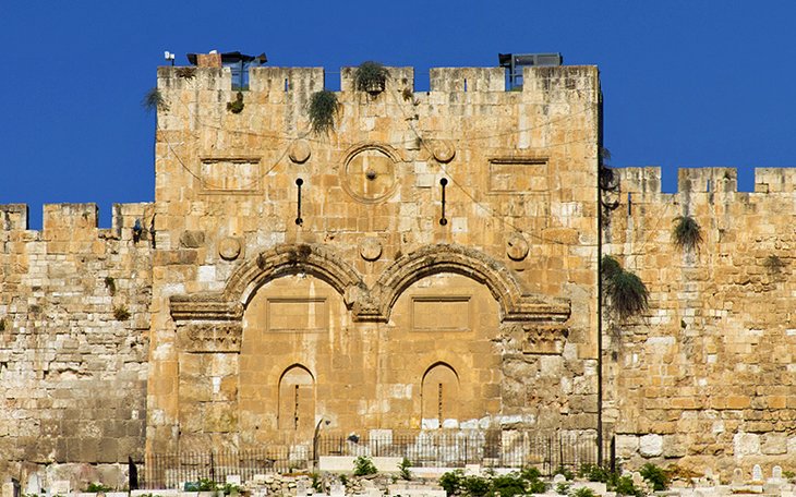
One of the most interesting features of the walls is the bricked-up Golden Gate; a double gateway through which Jewish tradition states the Messiah will enter the city on the day of the last judgement. Accordingly - and undoubtedly also with strategic considerations in mind - the Arabs walled up both gateways and for good measure laid out a cemetery outside the walls here.
Temple Platform
The site of Solomon's First Temple is now a spacious plaza. The western side features some arcaded Mameluke-era buildings. Between the gates ofBab el-Qattanin and Bab el-Hadid are a number of tombs, including that of Sharif Hussein I Ibn Ali (1851-1931), leader of World War I's Arab Revolt. At the southeast corner, a flight of steps leads down to the so-called Solomon's Stables (usually closed), a series of chambers built by Herod the Great, where the later Crusaders tethered their animals.
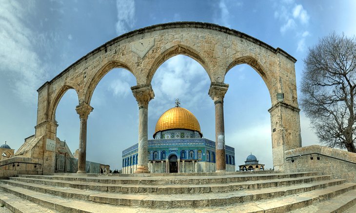
The steps that lead up to the central platform, where the Dome of the Rock sits, are spanned by handsome arched columns dating from the Mameluke period. Muslims call these the 'Scales' as they believe that the scales used to weigh the souls of men will be hung from here on the Day of Judgement.
Al-Aqsa Mosque
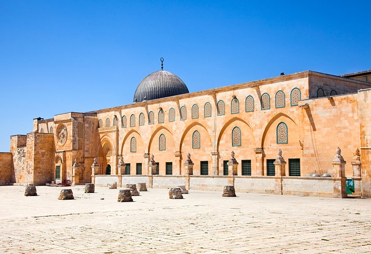
Al-Aqsa Mosque ('The Farthest Mosque') takes its name from the Prophet Muhammad's journey to heaven (known as al-Isra wal Mi'raj or 'the night journey' by Muslims) in which he traveled from Mecca to 'the farthest mosque' before ascending to heaven. Archaeologists believe that the mosque stands on the marketplace site of the Jewish Temple Mount. The original mosque was built during the reign of the Omayyad Caliph El-Walid I (AD 705-715), and some archaeologists believe that the builders overlaid a Byzantine-era basilica in the construction, though there is dispute about this. When the Crusaders arrived in Jerusalem, they decided the mosque was the true site for Solomon's Temple.
Across the centuries, Al-Aqsa has been extensively restored and renovated; most recently between 1938 and 1943, when columns of white Carrara marble, supplied by Mussolini, were installed and a new ceiling was built at the expense of King Farouk of Egypt. In 1967, it was damaged by gunfire and in 1969, a fire deliberately started by an Australian Christian, destroyed some of the priceless 12th-century interior detail. Despite this, the seven-aisled interior is impressive and is home to a striking and intricately-carved mihrab (prayer niche).
Outside the front of Al-Aqsa is the El-Kas ablution fountain, erected by the Mameluke Sultan Qaitbay in 1455.
Dome of the Rock Platform Buildings
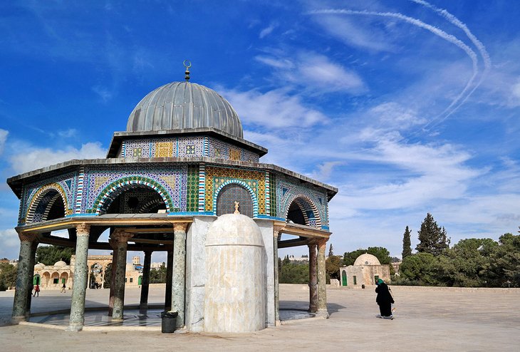
On the Dome of the Rock's eastern side is a small circular domed building known as the Dome of the Chain; so-called because Solomon is said to have hung a chain over his father's place of judgement from which a link would fall if any man appearing for judgement swore a false oath. The large mihrab (prayer niche), marking the direction of Mecca, dates from the 13th century.
At the northwest corner of the raised platform is the Dome of the Ascension, built on the spot where, in Muslim belief, the Prophet Muhammad prayed before his ascent to heaven. In the northwest corner, in front of the staircase are the Dome of St. George and the Dome of the Spirits which date from the 15th century.
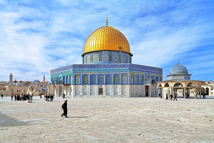
Dome of the Rock
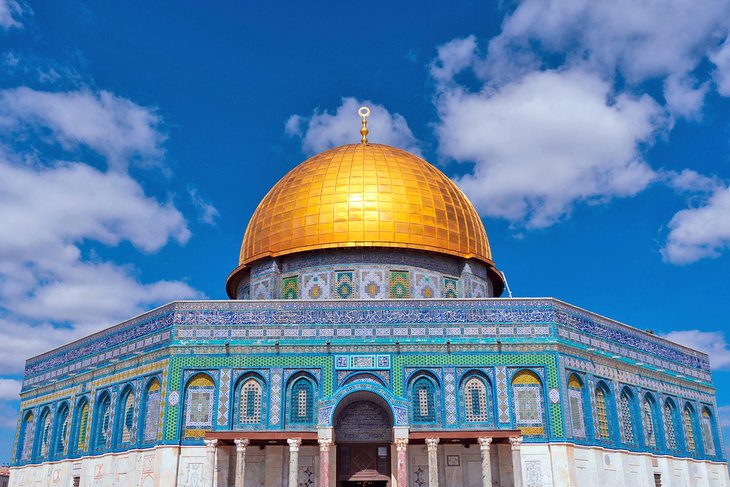
Built over the site where Jews believe Abraham prepared to sacrifice Isaac, and Muslims believe the Prophet Muhammad began his ascent to heaven, the Dome of the Rock (Qubbet el-Sakhra) is one of the greatest of Muslim monuments. It was built by Abd el-Malik (685-705), the fifth Omayyad Caliph. The octagonal structure, with a high dome, enshrines the sacred rock of Moriah. The impressive effect of the Dome of the Rock results from the combination of fine proportions and sumptuous decoration with an apparently simple ground-plan consisting of three concentric elements. Round the rock is a ring of piers and columns supporting the dome; a broad ambulatory separates this ring from an octagon, also formed by piers and columns; and this in turn is separated from the octagonal outer walls by a narrow ambulatory.
Four doors, clad with copper by Qaitbay (1468-96), lead into the interior, which is unfortunately off-limits to non-Muslims. In the center of the inner rotunda is Es- Sakhra, the Holy Rock, over which the Jews' altar for burnt offerings may have stood. Just under 18 m long by 13.25 m across, it is surrounded by a grille installed by the Crusaders in the 12th century to prevent relic collectors from breaking off pieces of the stone. Under the rock is a cave, known to Muslims as Bir el-Arwah ("Well of Souls"), where it is believed that the souls of the dead gather to pray.
Practical Haram al-Sharif Tips
- Haram al-Sharif is open Sat-Thu 7.30am-10am & 12.30pm-1.30pm (Oct-Mar), and Sat-Thu 7.30am-11am & 1.30pm-2.30pm (Apr-Sep).
- Non-Muslims can only enter from the Bab al-Magharibeh, next to the Wailing Wall in the Western Wall Plaza.
- Get here as early as possible. Security checks mean lines at entry can be long and tiresome.
- You can exit from any of the other gates. Exit from the Bab el-Qattanin to admire its grand stalactite architecture.
- You are entering one of the holiest sites in the world. Dress modestly.
Getting There
- From central Jerusalem, Egged Bus No. 38A runs from King George V Street through the Jewish Quarter and to the Western Wall Plaza and related tourist attractions.
- If you're walking from Central Jerusalem, Jaffa Gate is the nearest approach into the Old City.
History
For those of the Jewish faith, the Temple Mount is where the world began, with God bringing forth the earth, Adam, and Eve from the foundation stone of Mt Moriah. It was on this same stone that the Prophet Abraham signalled his devotion to God by agreeing to sacrifice his son. The First Temple built on this spot was constructed by King Solomon with the Ark of the Covenant stored inside. The First Temple was completely destroyed by Nebuchadnezzar in 586 BC. Later, a Second Temple was built here, which was obliterated by the Romans in AD 70.
Before the Muslims captured Jerusalem, the city was held by the Byzantine Empire, and Emperor Justinian dedicated a church to the Mother of God on the Temple Mount site.
After the Muslim armies conquered Jerusalem in AD 638, Caliph Omar visited the city. Simply dressed, and accompanied by Archbishop Sophronius, he entered the Temple precinct and said a prayer on Abraham's rock, which those of the Muslim faith believe to have been the site from where Prophet Muhammad ascended to heaven.
The brilliant period of the Omayyad Caliphs, whose capital was in Damascus, saw the erection on the Temple platform of the two buildings, which have become the landmarks and emblems of Jerusalem - the Dome of the Rock, built over the rock of Moriah by Abd el-Malik in 687-691, and the Al-Aqsa Mosque by his son El-Walid I (705-715).
The period of Muslim rule on the Temple Mount was interrupted by the coming of the Crusaders, who held Jerusalem from 1099 to 1187 and plundered the Dome of the Rock and the El-Aqsa Mosque (less generous than Caliph Omar, who had spared the church of the Holy Sepulchre). The first kings of Jerusalem resided in the Al-Aqsa Mosque, but later made it over to the Order of the Temple (founded 1149), which took its name from the Templum Salomonis (Al-Aqsa) and Templum Domini (Dome of the Rock). After Jerusalem was recaptured for Islam by Saladin in 1187, there was much further building on the Temple platform, particularly by the Mamelukes.
 Jerusalem - Temple Mount Map
1925 Wakf Temple Mount Guide or AL-HARAM AL-SHARIF - JERUSALEM - r2 - YJ Draiman

1925 Wakf Temple JERUSALEM
1925 Wakf Temple Mount Guide Temple
taken by force 16 pages.
Page 1 Cover and page 2 picture view of the Haram area from North to West
In 1925 Muslims that controlled Temple Mount
Before 637 CE/AD Jerusalem Lausanne
Read it for yourself and decide. Don’t take my word for it.
1925_Wakf_Temple_Mount_Guide.pdf
Text only transcription of the guide for ease of reading.
A Brief Guide To AL-HARAM AL-SHARIF JERUSALEM Temple Mount
Published by the Supreme Muslim Counsel
PRICE P.T. 15
The Sacred Enclosure will normally be open to visitors between 7.30 a.m. and 11.30 a.m. daily (Fridays excepted).
Admission may be gained by the gate known as Bab al-Silsileh.
-3-
IMPORTANT NOTICE.
Visitors should bear in mind that the whole of the Haram Area, and not only it’s edifices, is scared to Muslims; and that they will be expected to pay due regard to its sanctity. In particular, they must abstain from smoking anywhere in the Area, and from bringing dogs with them.
The visiting-hours are from7.30 a.m. to 11.30 a.m. daily, (Fridays excepted) and visitors are particularly requested to leave punctually at 11.30 so as not to hinder the observance of the midday-prayer.
Admission may best be gained by the gate known as Bab al-Silsileh. It would save trouble and delay if visitors were to make it a point of entering the Haram by that gate.
The visiting-hours are from
Admission may best be gained by the gate known as Bab al-Silsileh. It would save trouble and delay if visitors were to make it a point of entering the Haram by that gate.
N.B. The photographs in this Guide are reproduced by courtesy of the American Colony.
– 4 –
THE HARAM
–
HISTORICAL SKETCH
The words al-Haram al-Sharif, which can perhaps best be rendered by “The August Sanctuary”, denote the whole of the sacred enclosure which it is the object of this Guide to describe.
Its plan is roughly that of a rectangle whose major axis runs from north to south; its area is approximately 145,000 square meters.
If you wish to have some idea of its extent and to see it whole before proceeding to examine it in detail, you would be well-advised to begin your visit by walking to the north-west corner, and there ascending the flight of steps which lead up to the disused building on the right, you will see the whole area spread before you. The view shown on the frontispiece (Fig. 1) was taken, although at a considerable altitude, from the very spot where you are standing.
The two principal edifices are the Dome of the Rock, on a raised platform in the middle, and the mosque of al-Aqsa against the south wall. Other buildings which we shall consider later lie dotted about here and there. On the left along the east wall the double portals of the Golden Gate appear. On every side, trees break the prospect, which lend a peculiar charm to the scene.
The side is one of the oldest in the world. Its sanctity dates from the earliest (perhaps from prehistoric) times. Its identity with the site of Solomon’s is beyond dispute. This, too, is the spot, according to universal belief, on which “David built there an altar unto the Lord, and offered burnt offerings and peace offerings”. (1)
The side is one of the oldest in the world. Its sanctity dates from the earliest (perhaps from prehistoric) times. Its identity with the site of Solomon’s is beyond dispute. This, too, is the spot, according to universal belief, on which “David built there an altar unto the Lord, and offered burnt offerings and peace offerings”. (1)
But, for the purposes of this Guide, which confines itself to the Muslim period, the starting-point is the year 637 A.D. In that year, the Caliph Omar occupied Jerusalem Jerusalem
With the reign of’ Abdul-Malek ibn Marwan, the Umayyad, 685-705 A.D., the history of the present buildings begins.
With the reign of’ Abdul-Malek ibn Marwan, the Umayyad, 685-705 A.D., the history of the present buildings begins.
___
2 Samuel XXIV, 25.
Page 5 - Pic. The fountain Sabil of Qait Bay
– 6 –
was a holy city, to Muslims as well as to others, and to the energetic and pious caliph its glorification seemed an obvious duty. He collected large sums of money, amounting (say the Arab historians) to “seven times the revenue of Egypt
A new chapter begins with the capture ofJerusalem Temple
in the picture of “The Maries at the Sepulcher”, attributed to Hubert von Eyck. The mosque of al-Aqsa, on the other hand, was transformed in to a royal residence known as thePalace ofSolomon
The end of this chapter came in 1187, when Saladin capturedJerusalem
In the Dome of the Rock, he caused the walls to be covered with marble, and set up the beautiful inscription which may still be seen above the open gallery of the cupola.
He also restored the stucco incrustation of the inner dome, which remains to this day. In the mosque of al-Aqusa, he carried out restoration and embellishments, of which the chief were the fine mosaics on the drum of the dome and the beautiful pulpit adjoining the prayer-niche.
The Haram Area has remained in Muslim hands ever since.
For althoughJerusalem
In the reign of Sulaiman the Magnificent (1520-1566). This sultan whose works are still to be found all over theHoly City
A new chapter begins with the capture of
in the picture of “The Maries at the Sepulcher”, attributed to Hubert von Eyck. The mosque of al-Aqsa, on the other hand, was transformed in to a royal residence known as the
The end of this chapter came in 1187, when Saladin captured
In the Dome of the Rock, he caused the walls to be covered with marble, and set up the beautiful inscription which may still be seen above the open gallery of the cupola.
He also restored the stucco incrustation of the inner dome, which remains to this day. In the mosque of al-Aqusa, he carried out restoration and embellishments, of which the chief were the fine mosaics on the drum of the dome and the beautiful pulpit adjoining the prayer-niche.
The Haram Area has remained in Muslim hands ever since.
For although
In the reign of Sulaiman the Magnificent (1520-1566). This sultan whose works are still to be found all over the
Page 7 - Pic The Southern Arcades (Mawazine) and pulpits Burliancddin
– 8 –
both buildings have undergone different restorations which have for the most part marred rather than enhanced their beauty.
This is more particularly the case with the tiles on the exterior of the Dome of the Rock, which the hand of the restorer has here and there shifted or replaced most unhappily; and it is the present concern of the authorities of the Haram to try and undo the damage and restore to these decorative features something of their former harmony.
This is more particularly the case with the tiles on the exterior of the Dome of the Rock, which the hand of the restorer has here and there shifted or replaced most unhappily; and it is the present concern of the authorities of the Haram to try and undo the damage and restore to these decorative features something of their former harmony.
THE DOME OF THE ROCK
________________
________________
The Dome of the Rock stands on an irregular platform whose level is some 12 feet above that of the Area. It is approached from every side by flights of broad steps surmounted at the landing by graceful arcades (Fig. 3) known as Mawazin, that is to say ‘scales’, because of the traditional belief that on the Day of Judgment the scales of good and evil will be suspended there.
Having ascended the steps on the raised platform, you should, before entering the edifice, walk around it and examine it from the outside first. Its plan is that of a regular octagon inscribed in a circle of 177 ft. diameter. It has four entrances, each of which faces one of the points of the compass: on the West, The Bab al-Gharb, or west gate; on the north, the Bab al-Janna, or gate of paradise; on the east, the Bab Daud, or gate of David; and on the south, the Bab al-Qibla or south gate. This last gate fixes the direction in which prayers are to be said, namely the direction ofMecca
The tiles which form this decoration date for the most part from the end of the reign of Sulaiman the Magnificent (v. page 6) when the art of Oriental ceramic decoration was perhaps at its height.
Unfortunately, a great many of the original tiles have fallen off, and others have at various times been set in their stead without apparent regard for the harmony either of color or pattern. Still, the effect is striking and, especially in certain lights, beautiful.
The frieze is inscribed with verses from the Koran. Above rests the Dome, as rebuilt by the Caliph Hakem in 1022, slightly flattened on one side, and surmounted by the Crescent. The edifice itself is substantially that which was erected by ‘Abdul-Malek ibn Marwan; but the outer decorations that we have just seen are mostly due to Suliaman the Magnificent, and to later restorers.
Having ascended the steps on the raised platform, you should, before entering the edifice, walk around it and examine it from the outside first. Its plan is that of a regular octagon inscribed in a circle of 177 ft. diameter. It has four entrances, each of which faces one of the points of the compass: on the West, The Bab al-Gharb, or west gate; on the north, the Bab al-Janna, or gate of paradise; on the east, the Bab Daud, or gate of David; and on the south, the Bab al-Qibla or south gate. This last gate fixes the direction in which prayers are to be said, namely the direction of
The tiles which form this decoration date for the most part from the end of the reign of Sulaiman the Magnificent (v. page 6) when the art of Oriental ceramic decoration was perhaps at its height.
Unfortunately, a great many of the original tiles have fallen off, and others have at various times been set in their stead without apparent regard for the harmony either of color or pattern. Still, the effect is striking and, especially in certain lights, beautiful.
The frieze is inscribed with verses from the Koran. Above rests the Dome, as rebuilt by the Caliph Hakem in 1022, slightly flattened on one side, and surmounted by the Crescent. The edifice itself is substantially that which was erected by ‘Abdul-Malek ibn Marwan; but the outer decorations that we have just seen are mostly due to Suliaman the Magnificent, and to later restorers.
On the east side of the Dome of the Rock, facing the Bab Daub. or gate of David, stands an elegant little edifice, also surmounted by a dome, which look at first sight like a miniature representation of its larger brother. The room which supports the Dome and it’s drum rests on two concentric rows of columns neither of which is encased by walls. On the south side is a Mihrab, that is to say the prayer-recess. The edifice is variously known as Mahkamat Daud, (i.e. Tribunal of David) and Qubbat al-Silsileh (i.e. Dome of the Chain), from the legendary belief that on its site was the place of Judgments where verdicts were given by a miraculous chain. For as the legend has it, a chain was once suspended
Page 9 - Pic The Dome of the Rock (from the North-East)
– 10 –
from heaven over this spot, to which it was the practice in Solomon’s time to appeal in cases of conflicting evidence. Each witness was made to grasp the chain in turn: if he succeed in holding it, his truthfulness was thereby vindicated, but if it eluded his grasp, then he was a manifest liar. The edifice is said by some historians to be contemporaneous with the Dome of the Rock; but it is an established fact that it has been rebuilt more than once, albeit with the original columns which are in the Byzantine style and were undoubtedly taken from other buildings. Their number has varied: at the present time there are eleven in the outer, and six in the inner rows. (Fig. 4) We will now enter the Dome of the Rock (Qubbal al-Sakhra) by the west gate. The metal doors on either side of the entrance are worthy of notice; and inscription which was only recently discovered proves them to have been made and set up during the reign of the Mamluk Sultan Qait Bay, towards the end of the XVth. century. A few steps further, we find ourselves in the interior of the building. At first sight it is almost too dark to see; but as the eye gets used to the subdued light, the beauty of the structure and the splendor for the ornamentation reveal themselves. In the centre, vertically below the dome, is the Sacred Rock, an irregular mass of yellowish stone. This is where the Crusaders had set up an altar and traces can still be seen of the steps which once led up to it. The dome rests on an inner system of piers and columns forming a circle and connected with each other by a wrought-iron grille, dating from the XIIth. century — a unique remnant of the Crusaders’ decorations. This inner row is formed of four rectangular piers, beautifully adorned with marble facings dating from the XVth. century, and twelve monolithic columns with Byzantine capitals carrying semicircular arches. Above is the drum with its rich mosaics, its delicate inscription on bands and medallions, and 16 windows; while, resting on the rim above the clerestory windows, is the inner (wooden) cupola, with its remarkable stucco ornamentation, ordered by Saladin in 1189.
Concentric with inner system which we have just described is the outer octagonal row of piers and columns supporting the roof. The piers in this row are eight in number and are of massive size, covered with XVth. century marble facings; while the columns, of which there are sixteen, are marble monoliths
taken from some older building, probably Hadrian’sTemple of Jupiter
Concentric with inner system which we have just described is the outer octagonal row of piers and columns supporting the roof. The piers in this row are eight in number and are of massive size, covered with XVth. century marble facings; while the columns, of which there are sixteen, are marble monoliths
taken from some older building, probably Hadrian’s
Page 11 - Pic The Rock
– 12 –
name as that of the Caliph al-Mamun who reigned in A.H. 197-218: an obvious anachronism, of which the explanation is that the name of the later Caliph was substituted for that of his predecessor, ‘Abudul-Malek ibn Marwan , the real builder of the Dome of the Rock, while the original date remained unchanged.
The walls of the edifice, which as we have seen form a regular octagon, are covered with marble slabs and pierced with windows dating, for the most part, from Sulaiman’s restorations.
The slabs are of beautiful marble specially chosen for its smoothness and remarkable veining. The windows are made of plaster, and their pattern consists of an intricate openwork tracery in which are inserted bits of colored glass. The effect is one of great softness and richness of color, and this is partly due to
the skill with which the tracery is hollowed out of the plaster and cut away towards the inside in such a way that the openings become provided with a kind of cone for the softer diffusion of the rays of light.
A detailed description of the Dome of the Rock would be beyond the scope of this Guide. Its principal features have been mentioned and described in sufficient detail, it is believed, to give the visitor an adequate summary of its history and some help towards the appreciation of its magnificence.
THE MOSQUE OF AL-AQSA
____________________
____________________
Leaving the Dome of the Rock by the west gate, the visitor will notice, some 50 yards away on the right, a small octagonal domed edifice of semi-oriental and semi-Gothic appearance. This is the Qubbal al-Mi’raj or Dome of the Ascension. It was originally built in commemoration of the Prophet’s miraculous ascension, and rebuilt in its present form about the year 1200 A.D., that is to say some thirteen years after the capture of the Holy City
The monument is not open to visitors.
Turning towards the south, we cross the platform to the arcades on its southern side, passing on the way the marble pulpit of Burhaneddin (Fig. 3) which was built by the judge of that name in the middle of the XVth. century. The pulpit is crowned by a dome supported by trefoil arches resting on columns,
and is an interesting as well as a beautiful example of the work of that period. Beyond the pulpit are the steps leading down to the court of the mosque of al-Aqsa. Immediately in front is the fountain of ablutions, and beyond that is the mosque itself.
The porch, which is the most recent part of the building, was added by the Sultan al-Mu’azzam, a nephew of Saladin, in the XIIIth. century. An inscription above the middle archway records the date as 634 A.H. (1236 A.D.). The porch consists of a facade of seven pointed arches, corresponding to the seven
front doors of the mosque, and affords yet another example of the Crusaders’ influence, although not a very happy one.
The interior of the mosque is unfortunately only partly accessible
Page 13 - Pic The Al-Aqsa Mosque (front)
– 14 –
to visitors at the present time, on account of the considerable repairs which have to be carried out to that part of the buildings which supports the dome. But visitors are admitted to the nave and aisles and can gain some idea of the whole. The nave, formed by two rows of massive columns with capitals, is the oldest part of the mosque. On either side of it, is an aisle, both of which date also from the earliest period; the outside aisles are of more recent construction. The columns of the nave were probably taken from Justinian’s basilica; while the capitals, which are mostly of the acanthus-leaf and wicker-work patterns,
date from Byzantine times and are probably contemporaneous with the construction of the mosque itself. The columns support a system of pointed arches of which the exact date is not known for certain. Their pointed form, however, shows plainly that they belong to a later period that the VIIth. century, for in that period the pointed form had not yet been evolved and the horse-shoe arch, as we have seen in the interior of the Dome of the Rock, was still prevalent. The columns are connected by wooden tie-beams, which as we have seen (page 10) is a device characteristic of early Arab monuments. Above the arches are two rows of windows; the lower open on the inner aisles, the upper are clerestory windows admitting air and light from the outside. (Fig. 7).
Above the crossing stands the dome resting on a circular drum supported by a system of arches and pedantries, which are themselves borne at the tour corners by groups of pillars and capitals. The dome, which is of wood protected on the outside by a covering of lead sheeting, is ornamented with a handsome stucco incrustation of the same style as that of the dome of the Qubbat al-Sakhra. This decoration may, like its counterpart in the Sakhra, date from the time of Saladin; but be this as it may, it was completely renovated, if not actually made in the first instance, but the Sultan Muhammad ibn Qalaun in the year 728 A.H. (1327 A.D.), as the beautiful inscription on the blue band around the cupola testifies. The drum and the four arches with their pedantries are covered with a beautiful mosaic on a gold ground dating from the end of the XIIth. century, that is to say from the restoration carried out by Saladin (v. page 6).
To the west of the crossing runs the broad transept with its colonnade of pillars taken from older buildings. A few interesting Byzantine capitals of wicker-work design are worth noticing. The transept is continued into a vaulted gallery which dates from the occupation of the Crusaders, and was used as quarters by the Knights Templar.
The Mihrab (or prayer recess) in the south wall, facing the nave, is ornamented with mosaics and flanked with splendor and elegant marble columns. According to an inscription in mosaic above the niche, the work is due to Saladin. To the right of the Mihrab stands a handsome pulpit made of wood and beautifully ornamented with inlaid ivory and mother-of-pearl. It was made inAleppo Jerusalem
date from Byzantine times and are probably contemporaneous with the construction of the mosque itself. The columns support a system of pointed arches of which the exact date is not known for certain. Their pointed form, however, shows plainly that they belong to a later period that the VIIth. century, for in that period the pointed form had not yet been evolved and the horse-shoe arch, as we have seen in the interior of the Dome of the Rock, was still prevalent. The columns are connected by wooden tie-beams, which as we have seen (page 10) is a device characteristic of early Arab monuments. Above the arches are two rows of windows; the lower open on the inner aisles, the upper are clerestory windows admitting air and light from the outside. (Fig. 7).
Above the crossing stands the dome resting on a circular drum supported by a system of arches and pedantries, which are themselves borne at the tour corners by groups of pillars and capitals. The dome, which is of wood protected on the outside by a covering of lead sheeting, is ornamented with a handsome stucco incrustation of the same style as that of the dome of the Qubbat al-Sakhra. This decoration may, like its counterpart in the Sakhra, date from the time of Saladin; but be this as it may, it was completely renovated, if not actually made in the first instance, but the Sultan Muhammad ibn Qalaun in the year 728 A.H. (1327 A.D.), as the beautiful inscription on the blue band around the cupola testifies. The drum and the four arches with their pedantries are covered with a beautiful mosaic on a gold ground dating from the end of the XIIth. century, that is to say from the restoration carried out by Saladin (v. page 6).
To the west of the crossing runs the broad transept with its colonnade of pillars taken from older buildings. A few interesting Byzantine capitals of wicker-work design are worth noticing. The transept is continued into a vaulted gallery which dates from the occupation of the Crusaders, and was used as quarters by the Knights Templar.
The Mihrab (or prayer recess) in the south wall, facing the nave, is ornamented with mosaics and flanked with splendor and elegant marble columns. According to an inscription in mosaic above the niche, the work is due to Saladin. To the right of the Mihrab stands a handsome pulpit made of wood and beautifully ornamented with inlaid ivory and mother-of-pearl. It was made in
Page 15 - Pic The Al Aqsa Mosque (interior)
– 16 –
THE SUBSTRUCTURES
_______________
Leaving the mosque of al-Aqsa by the front entrance, we turn to the left and proceed to the south-east corner of the Haram Area where a staircase leads down in to the vast subterranean substructures known as Solomon’s Stables. The first flight of steps takes us down to the small chamber, now used as a place of Muslim worship, which was believed in medieval times to have been associated with Jesus Christ’s infancy. This belief was prevalent long before the advent of the Crusaders and was subsequently accepted by them. In the angle between the west and south walls of the chamber is a little dome borne upon four marble columns; and underneath the dome is a small niche lying horizontally, which was believed in early times to have been the Cradle of Christ and referred to under that name by several Arab historians.
In the west wall of the chamber, a door opens into a staircase descending to Solomon’s Stables. This is a vast subterranean chamber, of roughly rectangular shape, of which the chief feature is the imposing size of the piers. Of these, there are fifteen rows of varying size and height supporting the vaults on which rests the roof. Little is known for certain of the early history of the chamber itself. It dates probably as far back as the construction of Solomon’sTemple Jerusalem
The substructures supporting the nave of the mosque of al-Aqsa are not accessible.
______________________________________
In the west wall of the chamber, a door opens into a staircase descending to Solomon’s Stables. This is a vast subterranean chamber, of roughly rectangular shape, of which the chief feature is the imposing size of the piers. Of these, there are fifteen rows of varying size and height supporting the vaults on which rests the roof. Little is known for certain of the early history of the chamber itself. It dates probably as far back as the construction of Solomon’s
The substructures supporting the nave of the mosque of al-Aqsa are not accessible.
______________________________________
The best way out is across the esplanade, past the porch of the mosque of al-Aqsa, and back to the Bab al-Silsileh. An alternative would be to continue northwards past the Bab al-Silsileh to the gate known as Bab al-Quttanin, a handsome gate dating from the reign of Sultan Muhammad ibn Qalaun (1336 A.D.) and typical of XIVth century Arab work. To the south-east of this gate is the Sabil (or drinking fountain) built about the year
1460 A.D. byMamluk Sultan Qait Bay
1460 A.D. by
G. A.
___________________________________
___________________________________
Franciscan Printing Press,
1925 Wakf Temple Mount Guide Temple
In 1925 Muslims that controlled Temple Mount produced this guide which as it turns out is a pretty accurate history showing that they do NOT hold the original claim to the mount, but instead, took it by force. Admitting that even their own scholars admit it belonged to the Jewish people.
8 Top-Rated Tourist Attractions in Nablus
Historic Nablus is less visited than the southern towns of Bethlehem andHebron in the Palestinian Territories, but for those who want to explore the West Bank more thoroughly, this town has many attractions to offer. Its history stretches right back to Abraham's arrival in the land of Canaan, and important religious sites are scattered throughout the surrounding area. Mount Gerizim, with its Samaritan community, is a major highlight as are the twisty lanes of Nablus' Old City.
1 Old City
Nablus Old City district is a delight to explore. In sharp contrast to the tall office blocks of the surrounding modern districts, the maze of winding lanes and skinny alleyways here are a wonderfully atmospheric place of old and dilapidated stone buildings. In the center of the market area is theEl-Nassar Mosque, while the larger El-Kebir Mosque, built in 1168 on the foundations of a Crusader church, is a few hundred meters east. If you're looking for a unique gift to bring home, Nablus Old City is home to a thriving olive-oil soap production industry and there are several soap factories tucked within the alleys where you can watch the process and buy the wares.
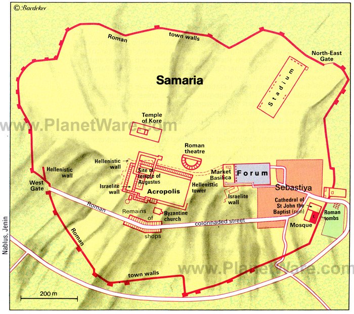
2 Sebastiya (ancient Samaria)
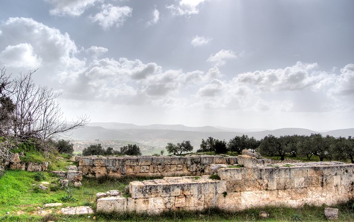
The extensive remains of Sebastiya (ancient Samaria) lay above the Arab village of the same name. This was the capital of the kingdom of Israel from 880-721 BC, founded by King Omri and his son Ahab, who also did much of the building works at Megiddo. With the conquest of Samaria by the Assyrian king Shalmaneser in 722 BC, the kingdom ceased to exist. Subsequently Samaria was used as a military base by Assyrians, Babylonians, and Persians. At the end of the 4th century, it was occupied by Macedonians and was Hellenised. Herod brought new splendour to Samaria, rebuilt the town, and renamed it Sebaste in honour of Augustus (in Greek Sebastos). Here, too, he had his wife Mariamne and her two sons put to death. Sebaste's prosperity was short-lived. Jewish rebels set fire to the temple of Augustus, and soon afterwards, in AD 69, Vespasian razed the fortress to the ground. In the Byzantine era, a community grew up in the town under their bishop, and when, in the 5th century, relics of St. John the Baptist were said to be found here, pilgrims began to come to the town. The cult of the saint's relics has continued down the centuries, and they are still revered in the mosque in the modern village of Sebastiya.
The ruins are centered round the Forum where, at the western end, a three-aisled basilica from the Byzantine era can still be seen. An ancient street, flanked by columns, leads from the Forum to the well-preservedWest Gate. Originally built by King Omri, what you see now is from the later Greek and Roman periods. From the Forum's northwest corner, a path runs up to the Acropolis, trailing past a 9th-8th century BC Israelite well, Hellenistic tower, and Roman theater. A monumental flight of steps leads up to the site where a palace, built by King Omri and his Phoenician wife Jezebel, and later a Herodian temple of Augustus would have sat. No trace of either remains. From the Acropolis, if you walk in an anti-clockwise direction around the site walls, you come to a well-preserved Byzantine church on the south side of the hill where, tradition states, John the Baptist's head was found.
Location: 11 kilometers northwest of Nablus
3 Mount Gerizim
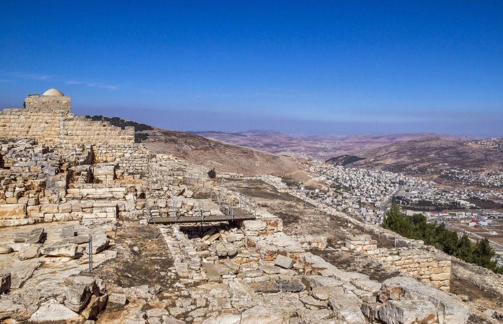
Mount Gerizim is home to 250 Samaritans. This tiny religious minority, which sprung from the Jews, who had escaped being deported to Babylon after the fall of the northern kingdom of Israel in 721 BC, can now only be found in the village of Kiryat Luza on Mount Gerizim's slopes and in Holon, near Tel Aviv. Although the Samaritan religion is related to Judaism, it is also distinctly different. Their Torah scroll contains only the five books of Moses, and their shrine is on Mount Gerizim, which they believe to be where God created the world and where Abraham proved his loyalty to God by nearly sacrificing his son. In Kiryat Luza you can visit the Samaritan Museum and then stroll to the site of the Samaritan Temple (destroyed in 128 BC).
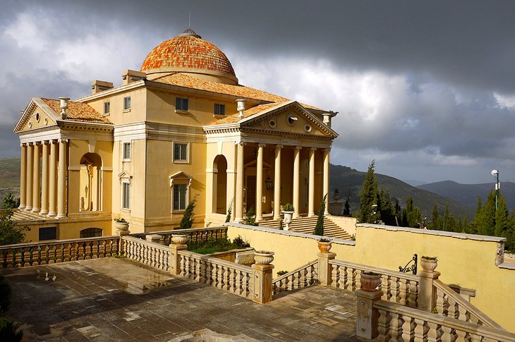
4 The Palladio (House of Palestine)
This rather surprising sight on Mount Gerizim is an exact replica of Andrea Palladio's Villa Capra in Vicenza. It's the work of Palestinian businessman Munib R Masri, who fell in love with Palladian architecture on a trip to Italy. It's not open to the public but you can admire the sheer audacity of this bizarre piece of 16th-century architecture from afar.
5 Balata Religious Sites
Next door to Balata Refugee Camp are several important historic sites.Jacob's Well is traditionally believed to have been dug by Jacob and also believed to be the well at which Jesus met the woman of Samaria. Around AD 380, a cruciform church was built on the site, which in later centuries was destroyed and rebuilt several times. In 1885, the site was acquired by the Greek Orthodox who built the current St. Photina the Samaritan Church here over the well. A few hundred yards north is a building with a white dome known as Joseph's Tomb. Here, Joseph is said to have been buried by his father Jacob.
Location: 2 kilometers southeast of Nablus
6 Jenin
Jenin has been an important town on the main route from Jerusalem for centuries. In the 13th century, the Mamelukes, fearing incursions by the Crusaders, destroyed the coastal towns and built Jenin up into a staging-point for caravans on the route between Damascus and Egypt.
Until the early 1930s, the road from Jerusalem to Haifa and Galilee ran through Jenin, but with the development of Haifa as a port and the construction of the coast road via Hadera, the importance of Jenin declined. Today Jenin's Old City with its traditional bustling souk is just the type of labyrinth you can get happily lost in and remains well off most tourists' radars. Jenin is also home to the excellent Freedom Theatre,which stages a program of plays and other performances throughout the year.
Location: 42 kilometers north of Nablus
7 Shiloh
The village of Sinjil, which takes its name from the Crusader Raymond de Saint-Gilles (Count of Toulouse) is 6 kilometers from the site of ancientShiloh (Khirbet Seilun in Arabic; Shillo in Hebrew). In the early period of Israelite settlement, Shiloh was an important shrine for this was where the Tabernacle containing the Ark of the Covenant stood for a hundred years from about 1175 BC. Excavations by Danish archaeologists from 1926 onwards brought to light a temple of the Canaanite period. Although highly important from a religious perspective, there isn't much to see at the site and it's probably only of interest to the most enthusiastic history buff.
Location: 36 kilometers south of Nablus
8 Mount Sartaba
In the 1st century BC, the Hasmonean king, Alexander Jannaeus, built the fortress of Alexandria here on Mount Sartaba. Destroyed by the Romans, it was later rebuilt by Herod, and in 31 BC, served as a place of confinement for Herod's wife. It is a steep climb up the hill to the remains of the fortress, but the effort is rewarded by magnificent views from the summit extending southwest to the Mount of Olives in Jerusalem.
History
The site of Old Testament Shechem is 2 kilometers southeast of Nablus, on the saddle between Mounts Gerizim and Eval. An important town in Canaanite times thanks to its situation at the intersection of important roads running east-west and north-south, Shechem was associated with many events in the Old Testament.
Abraham set up camp here on his journey from Mesopotamia to Canaan and erected the first altar. His grandson Jacob also pitched his tent outside the town after his return from Mesopotamia, bought land for a hundred pieces of money, and also erected an altar (Genesis 33,18-20). In the 17th century BC, the Hyksos built a fortress here. In the 13th century BC, Joshua had the remains of Joseph brought from Egypt and buried in the field, which his father Jacob had bought. Later, when Omri founded the new capital of Samaria, Shechem lost its importance and declined into a village until 350 BC when the Samaritans made it their capital. The history of the town came to an end with its conquest by John Hyrcanus I in 128 BC.
In AD 72, two years after the destruction of Jerusalem, Titus founded the settlement of Flavia Neapolis (the "new city") 2 kilometers northwest of the ruined town of Shechem. The town flourished, and in 244 was granted the status of a colony. At first mainly populated by pagan veterans (time-served Roman soldiers) and Samaritans, it soon acquired a Christian community, which produced the philosopher and martyr Justinus (Justin Martyr, c. 100-165). In 521, the Samaritans killed the bishop and devastated the town's churches, whereupon Justinian had the rebels (except those who became converted to Christianity or managed to escape) executed or sold into slavery. In 636, the town of Neapolis was occupied by the Arabs and became known as Nablus. During the Crusader period, Queen Melisande, widow of King Fulk, fortified the town against her son Baldwin III, who, in 1152, excluded her from political life, but left her in possession of Nablus, where she founded a number of churches. The Crusader occupation of the town, however, was short-lived, and in 1187 it was recovered by the Arabs.
In 1936, Nablus was the starting-point of a rebellion against the British Mandatory authorities. Jordan seized Nablus in 1948, but it was retaken by Israel in 1967.
9 Top-Rated Tourist Attractions in Jericho
Jericho may not look like much at first but this is one of the oldest continuously inhabited towns in the world. Although you'd need to have more than a passing interest in archaeology to figure out the complicated layers on the tell (settlement mound), just standing on the top trying to get your head around the mammoth history is an awe-inspiring highlight for most tourists. The road between Jerusalem and Jericho has been a major highway through the centuries, and the area here is scattered with interesting attractions from the Jewish, Byzantine, and Muslim eras. No history lover should miss a trip here.
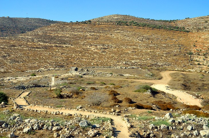
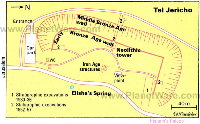
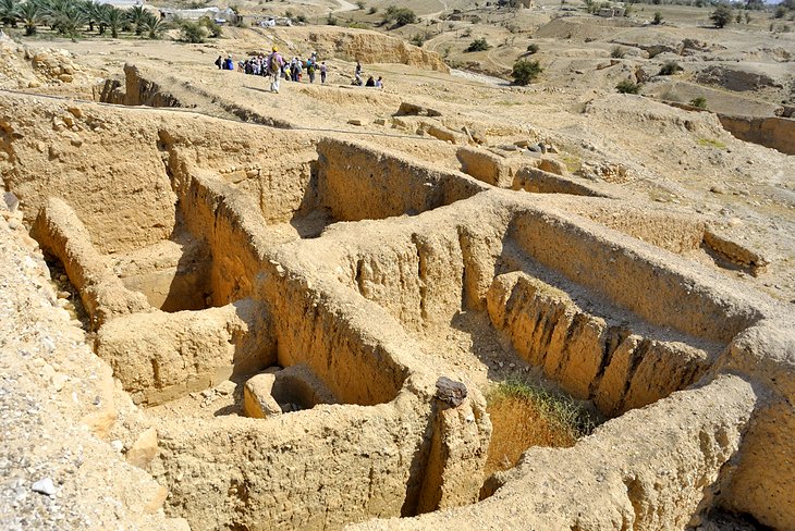
1 Jericho Tell
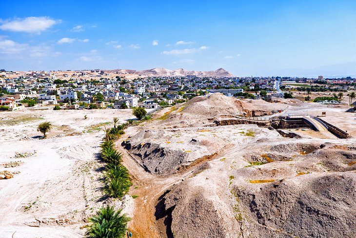
Just 2.5 kilometers northwest of Jericho's central square, opposite Elisha's Spring (also known as the Sultan's Spring) is the ancient 21-meter-high tell(settlement mound) of Jericho - also known as Tell al-Sultan. Archaeological investigation on this site began in 1860, but nothing of true importance was uncovered until the British excavations of 1930-31. The real breakthrough came with Kathleen Kenyon's investigations in the 1950s. She identified 23 occupation levels with the oldest traces of human settlement dating from around 8,000 BC. To the ordinary visitor, the remains of this early period in human history may not seem particularly sensational. The most noticeable feature is the broad trench, which archaeologists cut through the hill in order to investigate the various levels down to undisturbed soil. But the importance of this site in our understanding of human civilisation cannot be over-estimated. Jericho lays claim to the title of the world's oldest continuously inhabited town. In thetrench, you can see remains of the Neolithic town dating to approximately 7,000 BC, consisting of a section of the town wall and the 9-meter-high round tower built against it. On the east side, you see the entrance leading to 22 steps of a spiral staircase (the world's oldest staircase) and an opening higher up. To the north of this is a shrine made by Mesolithic nomads, dating from 8000 BC.
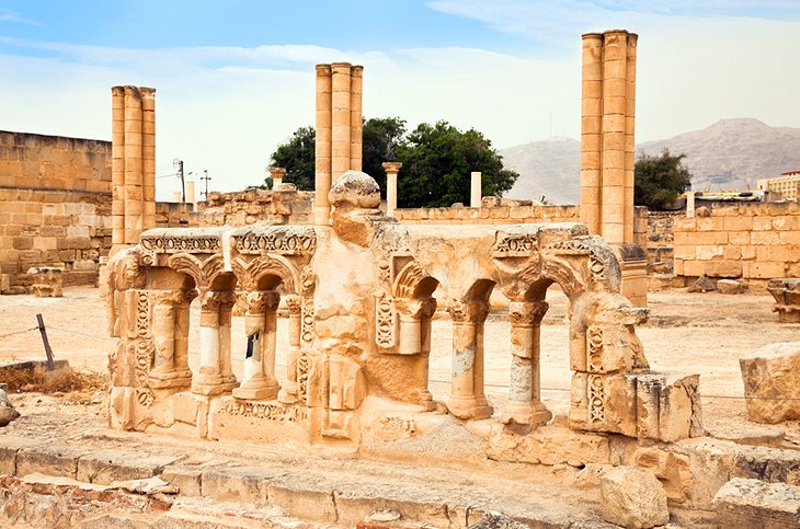
2 Hisham's Palace
This 8th-century palace was built by the 10th Omayyad Caliph Hisham in AD 724, but never completely finished. The earthquake of AD 746 destroyed it completely, and the site remained forgotten until British archaeologists excavated here in 1937. Numerous finds from the site, including the figural representations characteristic of early Islamic art, can be seen in the Rockefeller Museum in Jerusalem. The palace is laid out on a square plan, with four ranges of buildings opening off an inner courtyard and no entrances on the outside. Immediately north is a large bath housewith a bare ceiling, which originally contained alternating male and female figures and had a roof borne on sixteen pillars. In the bath house's northwest corner is a small room with an apse, no doubt a rest room or reception room for the Caliph. It is famed for its completely preservedmosaic, a work of consummate craftsmanship depicting three gazelles under an orange-tree, one of them being attacked by a lion.
Location: 2 km north of Elisha's Spring, Jericho
3 Mount of Temptation
Northwest of Jericho, the hillside of Qarantal plays an important role in Christian tradition. This is the Mount of Temptation where Jesus Christ fasted after being baptized in the Jordan River by John the Baptist. In AD 340, St. Chariton built a chapel on the hill summit and another was built by the cave in which Jesus is said to have sheltered. The Greek Orthodox Church acquired the site in 1875 and in 1895 built the Sarandarion Monastery (the name refers to the 40 days of Jesus' fast) halfway up the hill. From the monastery, a steep path runs up to the summit on which you can visit the remains of St. Chariton's original chapel. The views from the top across the arid hills are fantastic. For those that don't fancy the hike, there's a cable car to the summit from Jericho.
4 Wadi Qelt
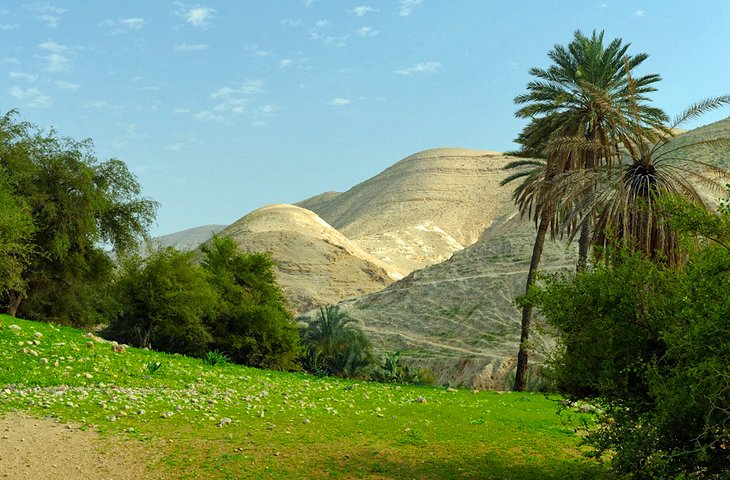
This lush valley is a tranquil slash of green amid the barren hills. It's a beautiful spot with gushing fresh water springs and palm trees, and the restful atmosphere has attracted ascetics for centuries. A number of monastery communities have set up camp here through the years, and Herod the Great built an aqueduct, which was repaired during the British Mandate. The Romans also built a road along this ancient route between Jerusalem and Jericho. In early Christian times, hermits lived in caves in this wild mountain country, which led to the foundation of St. George's Monastery here. It's a great place for a day hike or to just pack a picnic.
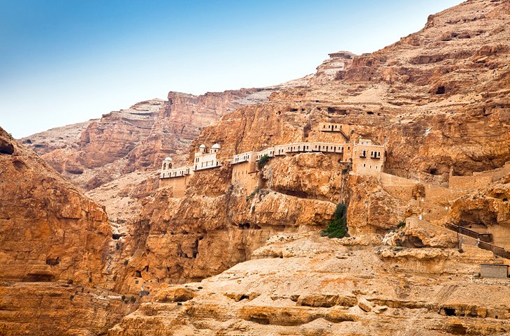
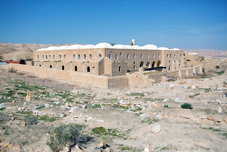
5 St. George's Monastery
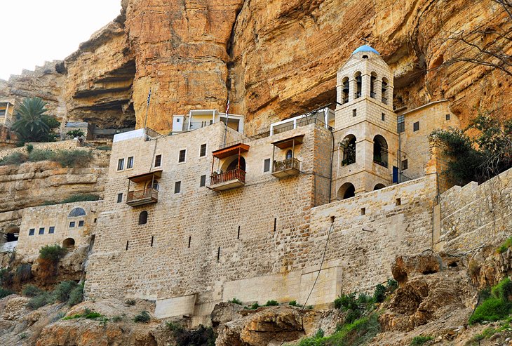
The Greek Orthodox Monastery of St. George clings precariously to the sheer north face of Wadi Qilt gorge. The monastery, originally dedicated to the Virgin Mary, was founded in AD 480. It was home to a flourishing monk population until it was destroyed by the Persians in AD 614 and afterwards, abandoned. The present buildings were constructed in the late 19th century and inside there are a number of interesting pieces of religious art. A stony path leads up to the main entrance for the monastery. Inside, the church dedicated to the Virgin Mary holds fine icons and frescoes, while the Church of St. John and St. George preserves a sixth-century mosaic pavement. In a cave nearby, are the remains of the monks who were killed during the Persian advance on Jerusalem.
Location: Jericho Road (20 km from Jerusalem)
6 Qasr el Yahud
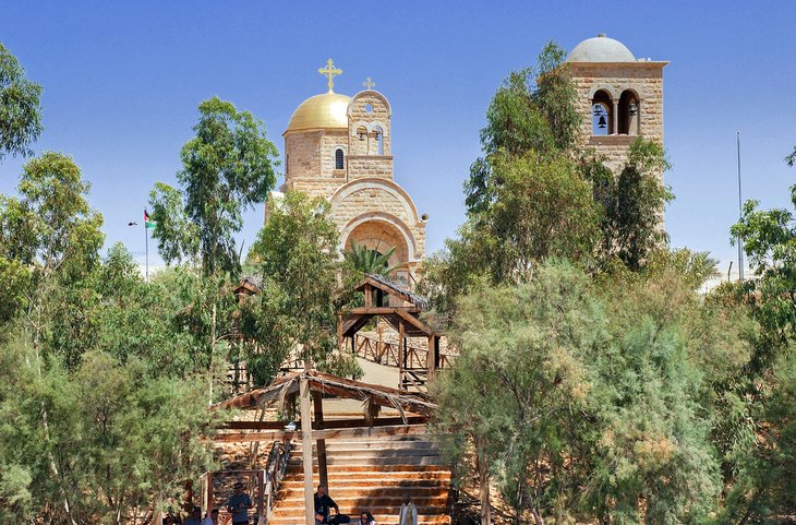
Right beside the Jordan River is Qasr el Yahud; one of the sites vying for the title of Bethany-beyond-the-Jordan where Jesus was baptized by John the Baptist. Across the murky, narrow, and shallow strip of the Jordan River is the other site on Jordanian territory, which has a much more solid case for the title after recent archaeological finds. Nevertheless, if you don't plan on visiting Jordan, this spot does just fine. It's popular with pilgrims immersing themselves in the water. If you do decide to enter the river, please remember you are not allowed to wade the three metres to the other shore. The Israeli and Jordanian armies keep watch on the other side.
7 Nabi Musa
The Islamic shrine of Nabi Musa (Prophet Moses) lies in the desert to the south of Jericho.
Although there is no proof that the Prophet Moses is actually buried here (and Mount Nebo in Jordan also vies for the title of his burial place), an old tradition since the Middle Ages claims this is Moses' resting place. Saladin knew about this place in the 12th century, and the Mameluke Sultan Baibars built a mosque here commemorating Moses. The mosque is commandingly situated on a hill where there is also a large cemetery for Muslims who wish to be near the prophet, even in death.
8 Inn of the Good Samaritan
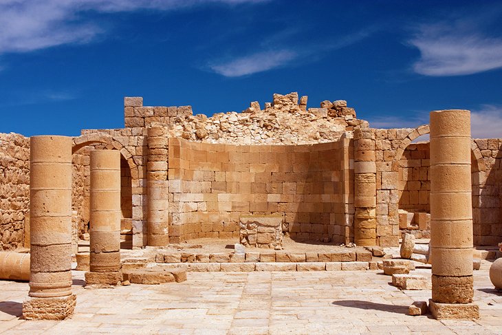
On the road between Jericho and Jerusalem, the Inn of the Good Samaritan commemorates the New Testament story of a robbed traveler taken under the wing of a passing Samaritan who brings him to a roadside inn to care for his wounds. Excavations here have uncovered a Jewish temple and a Byzantine church on this spot, and the museum beside the ruins is full of well-preserved mosaics and other finds from the site.
9 Hasmonean Palace
Excavations here have brought to light a large palace showing clear signs of Hellenistic influence. It is thought to have been built by the Hasmonean king Alexander Jannaeus (103-76 BC) and to have been occupied by the last Hasmonean rulers, and then by Herod, who enlarged and embellished it. While the palace at Masada was intended as a private residence, this palace was designed for official and state occasions. The palace stood in a park laid out with terraces and water channels and was built on a symmetrical plan around a spacious courtyard. Among the structures identified are a large audience chamber, rooms decorated with frescoes, Roman baths, and Jewish ritual baths. The most striking feature, however, is a large swimming pool measuring 32 meters by 18 meters and 4 meters deep, which archaeologists believe was the bath in which Herod had his 18-year-old brother-in-law Aristobulus drowned, only a year after he himself had appointed him high priest.
Location: 2.5 km west of Jericho
History
Descendants of the Mesolithic hunters who had first established a sanctuary by the spring at Jericho made remarkable progress. In the course of a period, which Carbon-14 evidence suggests is about a thousand years, they made the full transition from a wandering to a settled existence in what must have been a community of considerable complexity, for the imposing defences are evidence of an efficient communal organization. The inhabitants of Jericho in this period had a cult of fertility and of the dead. They covered the skulls of their dead with a layer of plaster and set them up in their houses. After the destruction of the town, either by war or in an earthquake, the site was occupied in the 6th millennium BC by men of a different race who had mastered the craft of pottery, but built very simple houses. In the Chalcolithic period (5th millennium BC), the settlement moved west to the mouth of the Wadi Qilt, perhaps because the spring had altered its position, but it soon returned to the original site. Square houses were now built within a strong outer wall.
The period around 2,000 B.C. is represented by pottery vessels in the form of human faces. In the Hyksos period (18th-16th century BC) a new town wall was built of rammed earth, with a pronounced batter. This town was destroyed about 1,400 BC.
The Bible gives a detailed account (Joshua 2-6) of the conquest and destruction of Jericho by the Israelites, coming from east of the Jordan. This event was formerly dated to the 15th century BC, but the 13th century (the time of Pharaoh Ramses II) is now considered a more likely date. In the distribution of territory, after the Israelites occupied the Promised Land, the Jericho area was assigned to the tribe of Benjamin (Joshua 18,21). In the reign of King Ahab of Israel (9th century BC) the destroyed city was rebuilt. During this period, the prophet Elijah and his disciple Elisha came to Jericho (2 Kings 2). Accordingly, the spring is known as Elisha's Spring.
In 586 BC, the Babylonians held the last king of Judah, Zedekiah, who had fled from Jerusalem, as a prisoner in Jericho, blinded him, and carried him off to exile in Babylon (2 Kings 25,7). During the Persian period, the tell of Jericho was once again abandoned as it had been in the 5th millennium. After 332 BC, the Hellenistic city of Jericho was built farther south, at the mouth of the Wadi Qilt. In 30 BC, Octavian (the future Emperor Augustus) gave the oasis to Herod, who made it his winter residence, built the fortress of Cyprus (named after his mother) to defend it, and died here in 4 BC. His body was then conveyed in a splendid cortege to the Herodeion.
The Hellenistic/Herodian city of Jericho was destroyed by the Romans in AD 70. Later, a settlement grew up on the site of the present town, to the southeast of the tell. A number of churches and a synagogue have been identified as dating from the Byzantine period. A new era began in 634 with the Arab conquest. The Omayyad Caliphs, ruling from Damascus, built a fortress and a mosque, and in 724, Caliph Hisham built a palace (Khirbet el-Mafyar). Thereafter, Jericho gradually lost importance, declining into a modest village.
Under the British Mandate, between the two world wars, the old Roman road through the Wadi Qilt was replaced by a modern road from Jerusalem to the Dead Sea and Jericho. In 1940, the town had a population of 4,000, who gained their living from the sale of bananas and citrus fruits grown in the oasis. The population has now risen to 7,000.
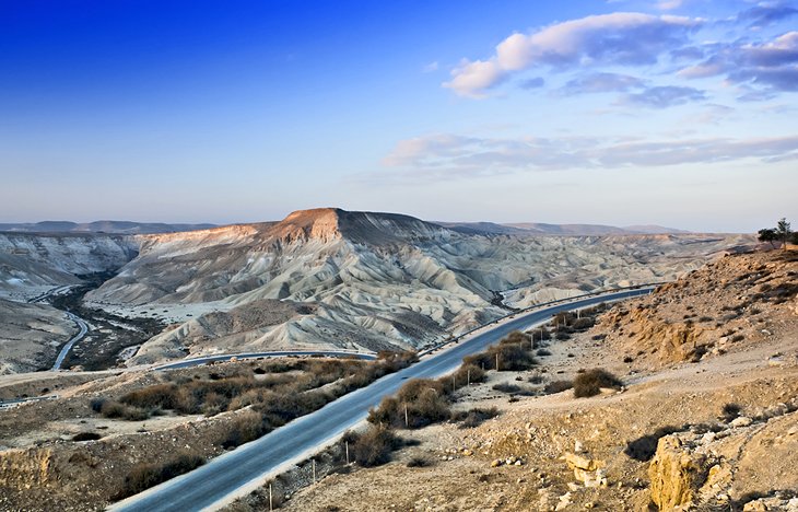
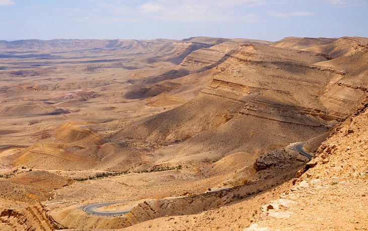
10 Top-Rated Tourist Attractions in the Negev Region
The Negev Region is a desert adventurer's dream packed with ancient ruins and drop-dead gorgeous desert scenery. Wilderness lovers will adore the weird and wonderful panoramas from the top of Makhtesh Ramon as well as exploring this natural highlight by 4WD or hiking. While the extraordinary old Nabataean caravan towns and UNESCO World Heritage sites of Shivta, Avdat, and Mampsis offer a feast of interesting history. Ruggedly handsome, the Negev is a star attraction for anyone who appreciates natural beauty.
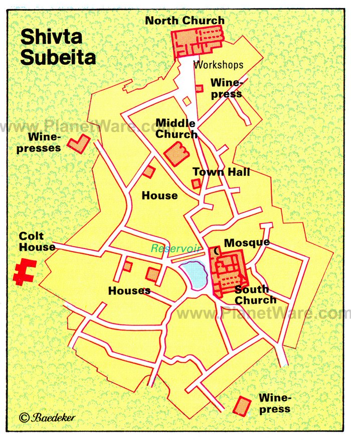
1 Shivta
Shivta (ancient Subeita) is home to the astonishingly well-preserved ruins of a 5th and 6th-century Byzantine city with three monastic churches, dwellings, water cisterns, and paved streets all visible. It was first built and used by the Nabataeans during the 1st century BC and later rebuilt by the Byzantines. Although the ruins are all from this later stage, Shivta earns its UNESCO World Heritage Site-status from its earlier Nabataean habitation, as part of the Desert Cities Incense Route in the Negev. On entering the site, you first come to the three-aisled basilica of the South Church. Built against the church is a mosque dating from the 7th century. A little way north of the church is the Council House, which stands at the intersection of two streets. Taking the street to the left brings you to the Middle Churchof which only a few sections of wall and the south apse survive. Continuing north, you pass through the craftsmen's quarter, with pottery kiln, workshops, and baker's oven, before arriving at the North Church.
Location: 55 kilometers southwest of Be'er Sheva
2 Nizzana
Nizzana is another Nabataean town, which continued to exist in Byzantine and Arab times until the 9th century. Excavations here in 1935 brought to light churches and other buildings. One of the churches has a mosaic pavement. Near the Bedouin well of Auja el-Hafir, the Turks built a frontier post in 1907, and during the period of the Mandate the British authorities sited a prison camp here. In 1948, the Egyptian army used Nizzana as a base for an attack on Be'er Sheva.
Location: 17 kilometers southeast of Shivta
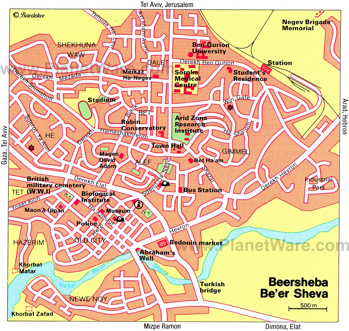
3 Be'er Sheva
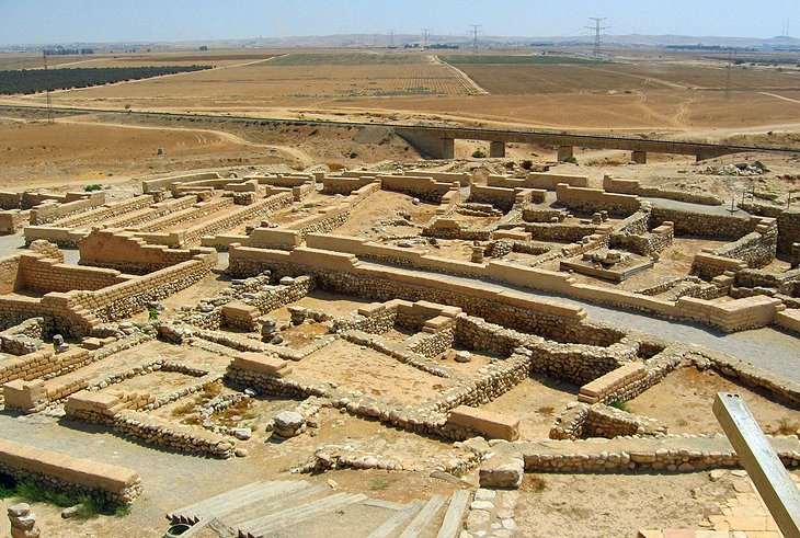
Famed in the Old Testament as the city of the Patriarchs, Be'er Sheva has developed within a few decades into the "capital of the Negev" and one of the largest cities in Israel. The earliest settlement in the area (Tel Sheva)lies on the eastern outskirts of the modern city. Excavation on the banks of the river has brought to light a Chalcolithic settlement of the 4th millennium BC occupied by semi-nomads, who constructed cisterns and underground dwellings entered from above. A number of finds from the site can be seen in the Israel Museum in Jerusalem. The main tourist attraction in town is the Thursday Bedouin Market (Eilat Road) where you can search out cushions, camel saddles, copperware, and numerous other craftwork. The Museum of Negev Art is on Ha'atzmaut Street, set in an Ottoman era building. At the southeast end of this street is a restored well, known as Abraham's Well (though it probably only dates from the Ottoman period). The main highlight of a visit to Be'er Sheva though is Tel Sheva, four kilometers northeast of the modern town. These are the remains of ancient Beersheba, and feature defensive walls and water channels.
4 Museum of Bedouin Culture
This museum, dedicated to Bedouin culture, has an intriguing ethnographic collection with exhibits of clothing, domestic equipment, jewelry, and various other everyday objects. The exhibits are well presented and provide an interesting introduction to the art and culture of the various Bedouin tribes of the Negev.
Location: Kibbutz Lahav, Joe Alon Centre, 20 kilometers northeast of Be'er Sheva
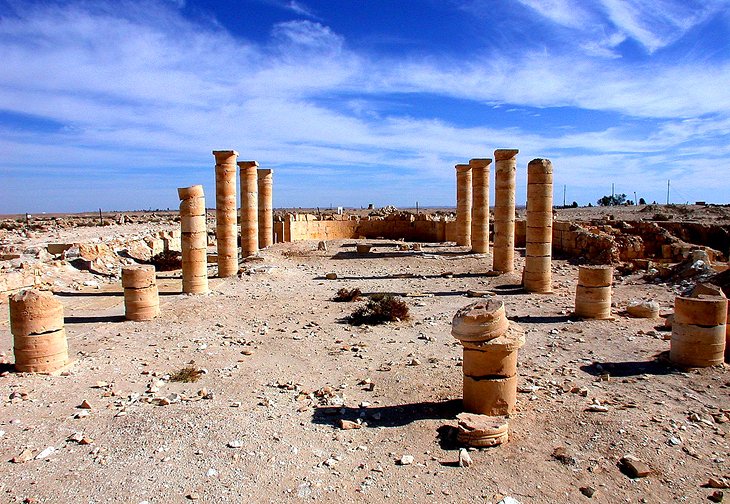
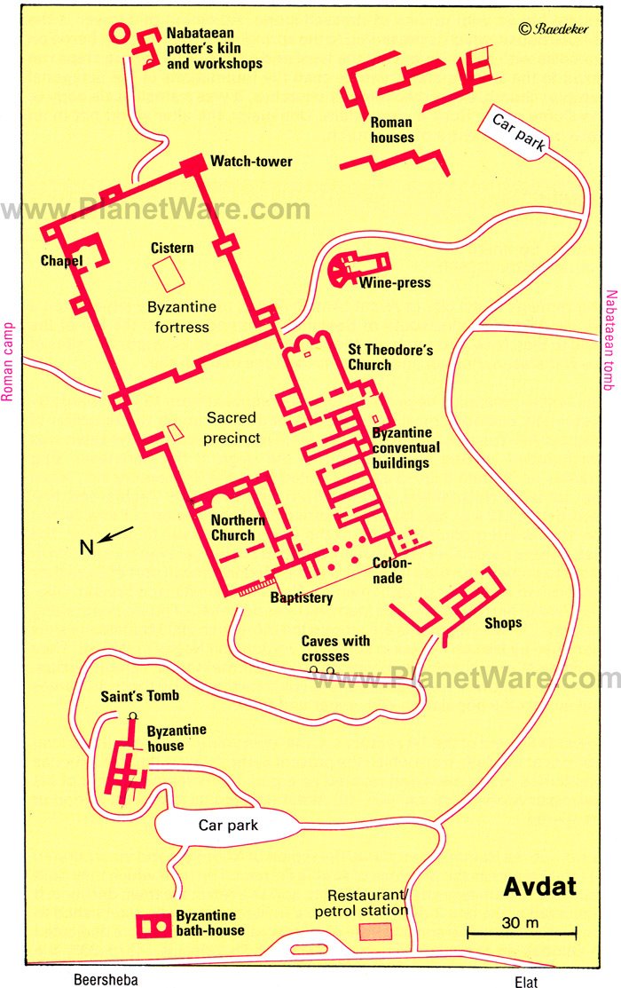
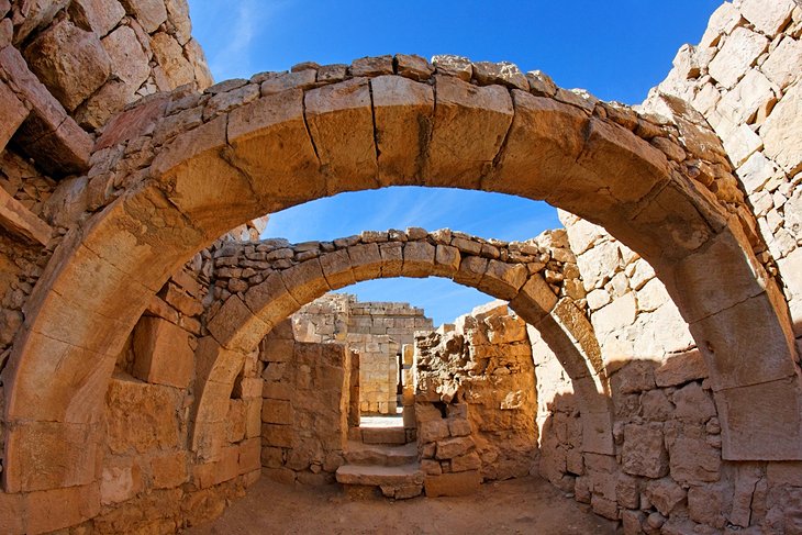
5 Avdat
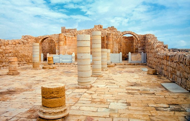
Prominently situated on a hill, the UNESCO World Heritage Site of Avdat(Avda in Arabic) is one of the most important sites of the Nabataean, Roman, and Byzantine periods in the Negev. It was first settled in the 3rd century BC when nomadic Nabataean tribes began to settle and take over the spice trade routes through the region. Later, the town thrived under Roman and then Byzantine occupation until finally being abandoned after the Arabs captured the town in AD 634. Just before the entry to the site proper, there is a Nabataean tomb with a doorway lintel relief depicting a horned altar flanked by the moon, sun, and a star. From the entry, a path leads north through a Roman era residential quarter where you can also see a stone bearing a Nabataean inscription. The path runs through the south gate into a rectangular Byzantine fortress. There is an excellent view over the entire site from the southeast corner here. Adjoining the western side of the fortress is a sacred precinct, which dates from the Byzantine period and contains two churches built on the sites of earlier Nabataean and Roman temples. Here, you find the Church of St. Theodore; a three-aisled basilica dedicated to a Greek martyr of the 4th century. Nearby, is the North Church with its preserved consoles supporting the roof beams in the southern aisle.
Location: 65 kilometers south of Be'er Sheva
6 En Avdat
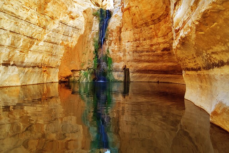
Near the Avdat ruins is one of the most surprising natural wonders of the Negev. The spring of En Avdat lies in the middle of a barren upland region of almost oppressive austerity. Here, four springs emerge from the rock, falling into a tranquil pool. Every morning and evening, the ibexes that live in the area come down to drink the water, so if you arrive at this time you can sneak some wilderness spotting into your itinerary as well.
Location: 65 kilometers south of Be'er Sheva
7 Mampsis
Ancient Mampsis (Hebrew "Mamshit", Arabic "Kurnub"), with its remarkable ruins, is the most northerly Nabataean town in the Negev and like Avdatand Shivta is a UNESCO World Heritage Site. Excavations between 1965 and 1973 brought to light a Nabataean settlement which had undergone little change in Byzantine times, so that its original character is better preserved than at Avdat, Nizzana, or Shivta. It was founded during the period when the Nabataeans, from their capital at Petra, set out to colonise the Negev. It prospered in the 1st century AD as a trading town with a caravanserai, stables, residential areas, and administrative buildings. After the fall of Nabataeans in AD 106, the Romans built barracks here. In Byzantine times (when Mampsis featured on the mosaic map at Madaba), the old Nabataean system of irrigation was brought into use again, as it was at Avdat, and two churches were built. The town was destroyed during the Arab conquest in the 7th century.
Entering through the north gate in the town walls, you continue along ancient streets between blocks of houses to two large administrative buildings. In one of the buildings, the arches have been preserved and it is possible to climb to the upper floor, from which there is a fine general view of the site. The West Church is built against the town walls. This aisled basilica was built by St. Nilus of Sinai in about AD 400. Immediately in front of the ruins of a police post from the British Mandate period, is the East Church, which was dedicated to the Holy Martyrs. It is approached by a broad flight of steps leading up from a square, which from Nabataean to Byzantine times was the market place. A mosaic pavement in the nave has been preserved. Other interesting buildings in Mampsis, identified by signs, include stables, a portico with Nabataean horn-capitals, and a building with well-preserved wall paintings.
To the west of the site, far below in the wadi, you can see the dams, which enabled the Nabataeans and Byzantines to store water during the short rainy season for use during the arid summer months.
Location: 42 kilometers southeast of Be'er Sheva
8 Sde Boker
The kibbutz of Sde Boker has close associations with David Ben-Gurion, Israel's first prime minister, who retired here. Ben-Gurion's House, with its interior largely unchanged since he died, can be visited and has a small, but interesting collection of photographs and letters. His and his wife's tomb, in a carefully tended cliff-top park, can also be visited. There are incredible views over the surrounding area from here.
Location: 50 kilometers south of Be'er Sheva
9 Makhtesh Ramon
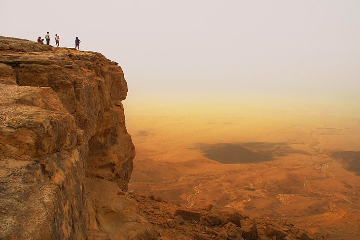
The largest of the three elliptical craters known as "mortars" (makhtesh) in the Negev is Makhtesh Ramon, which is 30 kilometers long by eight-kilometers wide. It is not a volcanic crater, but was formed 70 million years ago by the collapse of the land over underground cavities. Huge fossils of saurians, which lived 150 million years ago have been found here. The little town of Mitzpe Ramon has impressive views into the crater with the bottom 500 meters lower down.
On the east side are the remains of forts, notably Mezad Mishhor, built by the Nabataeans in the 1st century BC to protect the caravan route from their capital, Petra, to Avdat and via Subeita to Nizzana.
Location: 86 kilometers south of Be'er Sheva
10 Makhtesh Hagadol and Makhtesh HaQatan
Makhtesh Hagadol (the "Great Mortar") is the middle one of three erosion craters in the Negev, smaller than Makhtesh Ramon. Like Makhtesh HaQatan, the "Little Mortar", it lies to the north of the Wilderness of Zin. Both can be accessed via a hike. The best base is the town of Yeroham.
Location: 86 kilometers south of Be'er Sheva
History
The Negev seems to have become an arid area between 10,000 and 7,500 BC. In the 18th century BC, Abraham came from the north to Beersheba. In the later second millennium BC, the Negev was occupied by three peoples - to the north, around Arad, the Canaanites who had advanced farthest south; to the south, the Amalekites, whom David exterminated around 1,000 BC; to the east, around the Arava depression, the Edomites, who moved north in the sixth century BC, settled between Beersheba and Hebron, and became known as the Idumaeans.
From the first century BC, the Nabataeans sought to settle and cultivate the Negev from their capital at Petra. They achieved this with the help of ingenious methods of irrigation, and towns like Avdat, Subeita, and Mampsis were established. In the 4th-6th centuries the Byzantines took over from the Nabataeans and developed the region still further. After the arrival of the Arabs, who in other countries had improved irrigation methods, the irrigation systems of the Negev broke down, and for more than a thousand years, the Negev became an arid region inhabited by Bedouin.
The decisive impulse to make the land fertile again was given by David Ben-Gurion, a member of the kibbutz of Sde Boker, who established a university there for the study of the Negev. A scientific basis for the development of the region was provided by Michael Evenari, a botanist of German origin, who established a farm at Avdat using Nabataean methods and founded a plant research institute in Be'er Sheva. Of great importance for the resettlement of the Negev was the creation of the National Water Carrier, which brings water from northern Israel to the Negev.
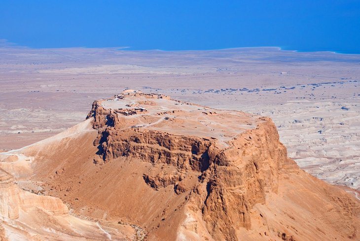
8 Top-Rated Tourist Attractions in Masada
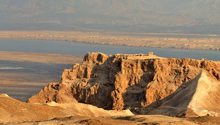
The UNESCO world heritage site of Masada plays a major role in Jewish history and is one of the most fascinating highlights of a visit to the Dead Sea region. It was here that the Zealots took their last stand against the Romans and committed suicide rather than allow Rome to take them as prisoners. Come here to explore the incredible ruins atop the lofty mountain and see the breathtaking panoramas across the Dead Sea. If you can, do sunrise here. The early morning wake up is worth it for the views from the summit.
1 Masada Museum
For the lowdown on Masada's importance, don't skip this museum in theMasada Visitor's Centre. It contains a fascinating collection of artefacts unearthed during excavations here and truly brings to life this stronghold's history. An audio guide is included in the admission price.
Admission: 20NIS
2 Paths to the Summit
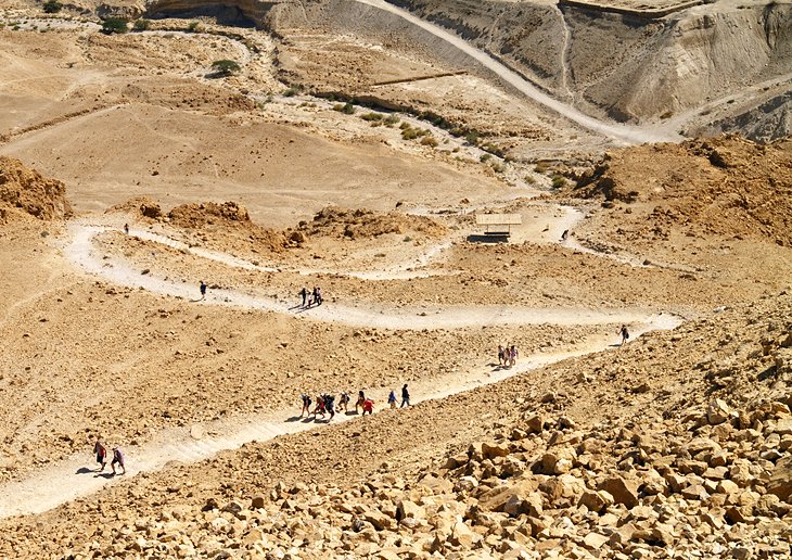
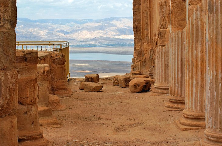
There are three ways to reach the summit. If you don't want to walk, then the cable car is your option, leaving every 10 minutes from the visitor's center and providing birds-eye views across the escarpment. For the active, there are two other ways to the top. Those that just want a short walk can take the Ramp Trail (from the western side of the mountain). And those who want the full experience can trek up the Snake Trail (from the visitor's center), which takes about one hour to hike with superb views all the way to the top.
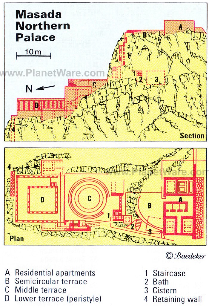
3 Northern Palace
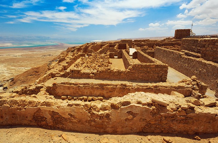
At the northern tip of the plateau is the monumental Herod's Northern Palace; a boldly conceived structure on three levels. The uppermost part, with Herod's residential apartments, ends in a semicircle from which there is a view of the two lower terraces reached on a modern flight of steps on the west side. On the way down, cisterns for water can be seen in the rock. On the middle terrace (20 meters lower down), which archaeologists concluded was designed to serve the purposes of leisure and relaxation, are two concentric rings of walls. Fourteen meters lower down is the square bottom terrace, a peristyle (courtyard surrounded by columns) with fluted Corinthian columns standing on a wall faced with painted plaster.
4 Baths
South of the Northern Palace is a bath house. A courtyard surrounded on three sides by columns leads into a changing room (apodyterium), which is paved with black and white triangular tiles. Adjoining this is the tepidarium(warm room), also with a tiled floor, the frigidarium (cold bath) and thecaldarium (hot bath). The caldarium - which has preserved its hypocaust (under-floor heating system) - is particularly impressive. The small piers of the hypocaust, more than 200 in number, originally supported a mosaic pavement. From the roof of the baths there is a good view of the whole fortress. Southwest of the baths is a building, which is believed to have housed Herod's work-rooms and offices. It contains a ritual bath (mikve) constructed by the Zealots between AD 66 and 73.
5 Synagogue
Against the fortress walls, excavators found the remains of one of the oldest synagogues in the world and the only one dating from the period of the Temple. The roof was borne on columns, and in the time of Herod, the building was divided into two parts by a wall. The Zealots altered the structure and installed stone benches. A number of scrolls, now in theIsrael Museum in Jerusalem, were found here.
6 Byzantine Church

Southeast of the synagogue are another large complex of buildings and achurch built by Byzantine monks in the 5th century. The church is entered through a porch or vestibule. The apse, at the east end, has a cavity in the floor, which may have housed relics. On the north side of the nave is a (partly preserved) mosaic pavement with representations of plants and fruits.
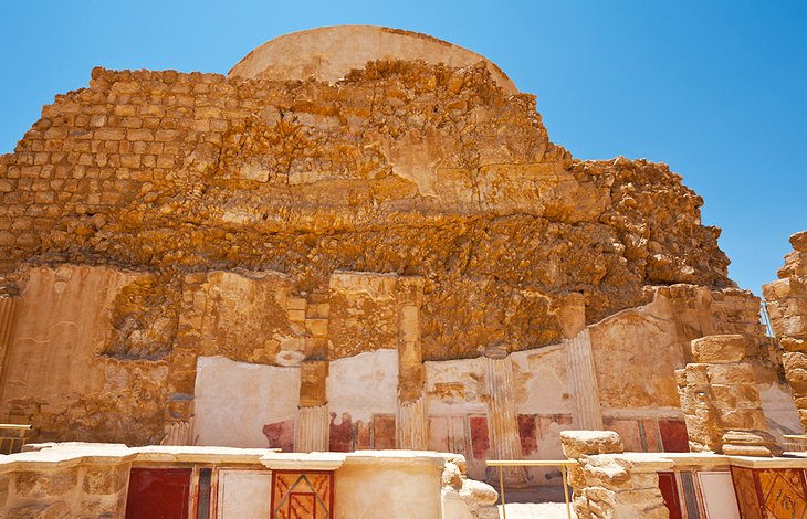
7 Western Palace
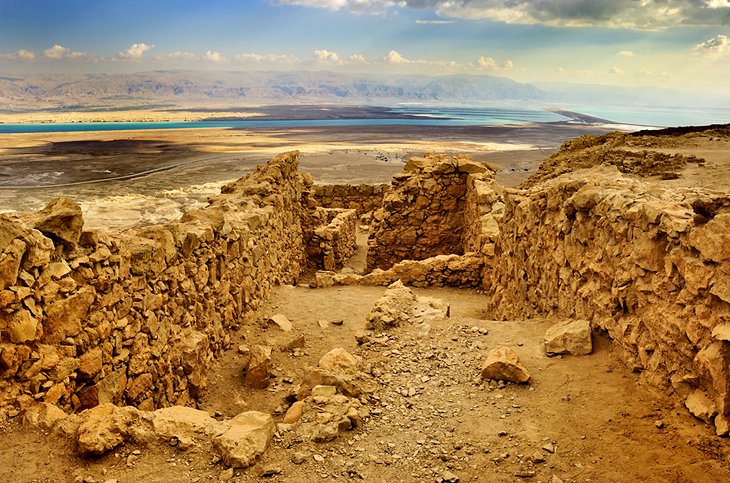
At the southern end of the plateau is one of the towers of the West Gate(opposite the Roman ramp) and the large Western Palace. Here, you can see how the Zealots altered the building to provide living accommodation and constructed another mikve to the southeast. While the Northern Palace was Herod's private residence, the Western Palace, which covers an area of some 4,000 square meters, was his official residence. The north and west wings contained domestic and administrative offices as well as accommodation for officials and servants. In the south wing, were the king's residential and state apartments. In one room, apparently an audience chamber, the excavators found a well-preserved mosaic pavement, the oldest ever discovered in Israel and the Palestine Territories, with geometric designs and plant motifs featuring vine and fig leaves and olive branches. At various points, where the pavement has been destroyed, you can see the guidelines used in laying the mosaic. Southwest of the Western Palace is a columbarium, a circular structure dating from the time of Herod with numerous niches for ash-urns, presumably to house the remains of non-Jewish members of Herod's garrison.
Going south from the columbarium, you pass two large open cisterns and come to the South Bastion at the southern tip of the plateau. On the way back along the eastern walls, there is a third mikve (at the South Gate), another cistern and houses dating from the Byzantine period (on left) and from the Zealot occupation (on right) before returning to the East Gate. From the eastern walls, there are magnificent views of the Dead Sea and the hills beyond with their ever-changing play of colour.
8 Sound and Light Show
Twice weekly (on Tuesday and Thursday) from March to October there is a fascinating sound and light show on the history of Masada, with light effects and background music, in the Masada amphitheatre (which can be reached only on the road from Arad).
History
The Jewish historian Flavius Josephus ascribes the first fortress erected on the hill to the high priest Jonathan. Herod enlarged the original small fortress into a stronghold, which combined royal magnificence with great defensive strength so that Masada became the fortress (metsuda) par excellence. In the troubled year 40 BC, when the Parthians chose the Hasmonean Antigonus as their leader, Herod brought his family and his betrothed wife Mariamne here for safety. Again in 31 BC, when Octavian defeated Antony and Cleopatra's fleet in the battle of Actium and Herod traveled to Rhodes to swear allegiance to the new master of Rome, Herod's family sought the safety of Masada, though this time Mariamne, along with her mother Alexandra, was taken separately to the fortress of Alexandria in Samaria.
Between 37 and 31 BC, Herod had turned Masada into an impregnable fortress. The summit plateau, covering an area 600 meters long by 200 meters wide, with its palaces, administrative buildings, store-rooms, barracks, and cisterns, was enclosed by a 1300 meters-long casemate wall reinforced by 38 towers, each 10 meters high. There were twelve cisterns, which together with the supplies of food in the store- rooms would enable the fortress to withstand a long siege.
This situation occurred some decades later, during the Jewish rising against Rome. In AD 66, even before the rising broke out, a group of Zealots - members of the radical party who had left Jerusalem as a result of internecine conflicts among the Jews - had established themselves on Masada under the leadership of Menachem Ben Judah. Soon afterwards, Menachem was murdered in Jerusalem and his nephew Eleazar Ben Yair assumed command on Masada. The Romans took the fortress of Herodeion, while the Zealot forces in the stronghold of Machaerus (in present-day Jordan), surrendered in return for a promise of free passage and thereupon reinforced the garrison on Masada, which finally was occupied by a total of 967 men, women, and children. After the fall of Jerusalem in the year AD 70, the defenders of Masada continued to hold out, and in AD 72, the Romans decided to overcome this last pocket of resistance by a siege.
Their commander, Flavius Silva, enclosed Masada within a circumvallation (siege wall) with a total length of 4,500 meters. Outside this, he built eight camps for the besieging forces; his headquarter camp, rhomboidal in plan, was on the west side. A great ramp was built up on the west side of the hill so that battering-rams and other siege engines might be deployed against the walls of the fortress. After an eight-month siege, the Romans broke through the walls and set fire to the timber stockade behind them.
Seeing that the situation was hopeless, Eleazar called on his companions in arms, in a speech recorded by Flavius Josephus ("Jewish War", VII,8,6-8), to die rather than be taken prisoner. They burned all their possessions except the stores of food (there since Herod's time), in order to show the Romans that they had not been starved into surrender. Then, although Jewish law forbade suicide, they chose ten men who were to put the rest of the defenders to the sword and then kill themselves. When the Romans took the fortress on the following morning they found 960 bodies. Two women who had hidden in a water conduit along with five children told them what had happened. "But when they discovered the great numbers of bodies they did not rejoice over their defeat of their enemies but admired the noble resolution and the unshakeable defiance of death shown by all those involved in the deed" (VII,9,2). This heroism, irrational though it might be, has made Masada a symbolic place for many Jews.
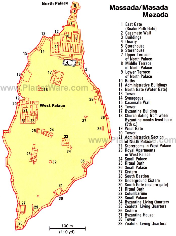
14 Top-Rated Tourist Attractions in the Sea of Galilee Region
Forever entwined with the story of Jesus Christ, who carried out much of his ministry work in the area, the Sea of Galilee region is a beautiful place full of ancient archaeological remnants and drop-dead gorgeous scenery. For Christians, of course, the main highlights are the collection of churches around Tabgha, built over the sites where Jesus carried out his miracles, but for other visitors, the placid lakeside scenery, hot pools, and hiking options in the surrounding hills provide enough of a reason to visit.
1 Tiberias
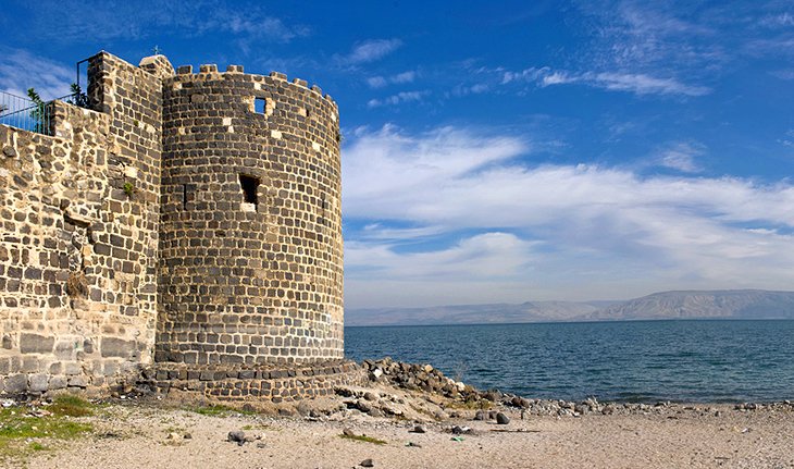
Sitting on the edge of the Sea of Galilee, Tiberias is the perfect base to explore this region. The waterside street Yigal Allon Promenade is home to most of the town's tourist attractions and is a great place for a lakeside stroll. Along this road you'll find the 19th-century Church of St. Peter, built over the remains of a Crusader castle. There's a beautiful cloister inside, and the apse of the church is projected like the bow of a ship - a reference to Peter's fishing boat. Just around the corner on HaYarden Street is the sculpture park known as the Open-Air Museum. If you walk south along the promenade, you come to the Greek Orthodox Monastery, erected in 1862. If you head inland from the sea, Tiberias is home to a number of important Jewish tombs. About 300 m from the northern end of HaGalil Street is the tomb of the great philosopher and physician Maimonides (Rabbi Mose Ben Maimon, also known as Rambam). Born in Cordoba in 1135, Maimonides left Spain because of religious persecution and went toCairo to become Saladin's personal physician. While there, he also became the spiritual leader of the Jews in Egypt. As well as the tomb there is an excellent museum here dedicated to his life and work. The tomb of Yohanan Ben Zakkai - who, after the destruction of Jerusalem in AD 70, founded a Jewish school in Yavne and transferred the seat of the Sanhedrin to that town - is also near here.
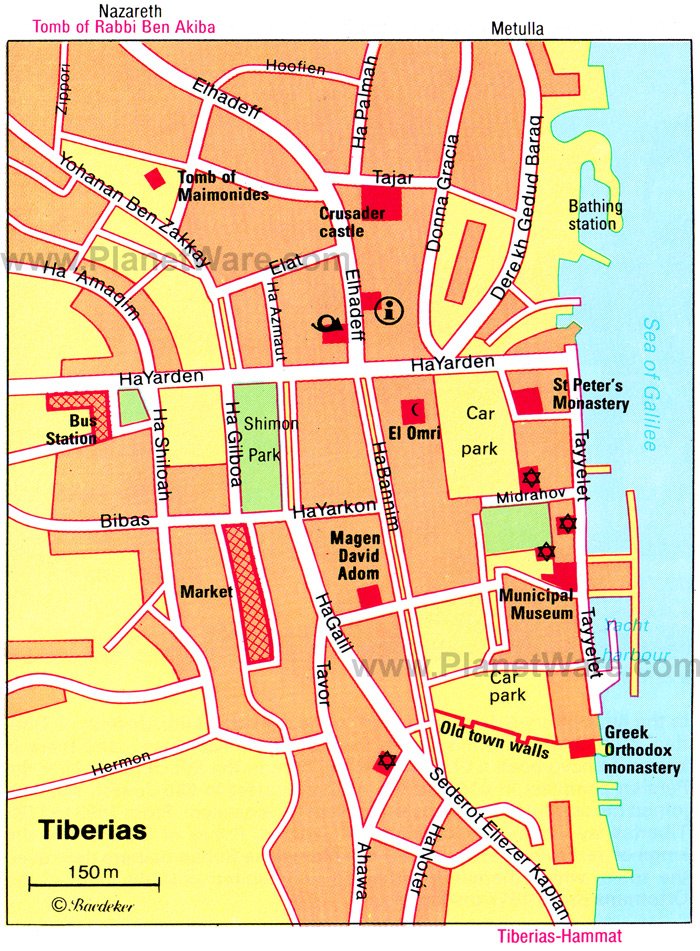
2 Tiberias-Hammat (hot springs)
Tiberias has been famed as a spa center since the Roman period, and itshot springs are as popular now as they were then. After you've finished having a soak, catch up on some history by visiting the fourth-centurysynagogue next door with its well-preserved, richly-patterned mosaic floor. The mosaic betrays the influence of Hellenistic and Roman culture even on pious Jews during this period with the central portion depicting the sun god Helios surrounded by the signs of the zodiac.
Location: 2.5 km from Tiberias town
3 Bet Yerah
The archaeological site of Bet Yarah ('house of the moon', also known as Khirbet Kerak) is not mentioned in either Biblical or Egyptian records, but excavations here have uncovered evidence of a settlement dating from the Bronze Age right through to the period of Arab rule. There are well-preserved remains of fourth- and fifth-century AD baths, and also the remains of a Roman fort from the third century AD. There is also a fifth-century three-aisled synagogue and a Byzantine church.
Location: 10 km south of Hammat hot springs
4 Arbel National Park
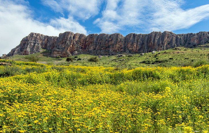
Arbel National Park is a wonderful place to put your hiking shoes on and hit the trail. The major attraction here is the walk up to the Horns of Hittim- the scene of a decisive battle during the Crusader period. On July 4th, 1187, Saladin inflicted an annihilating defeat on the Crusaders here. The Latin kingdom founded 88 years before now lost its capital, Jerusalem, and much of its territory; and for the remaining 104 years of its existence it was confined to a narrow coastal strip with its capital at Acre (Akko). It is a half-hour walk to the top of the hill on a footpath running up from the main road. From the summit, on which there are Bronze Age remains, there are fine views of Eastern Galilee and the Sea of Galilee.
Location: 10 km west of Tiberias
5 Kibbutz Ginosar
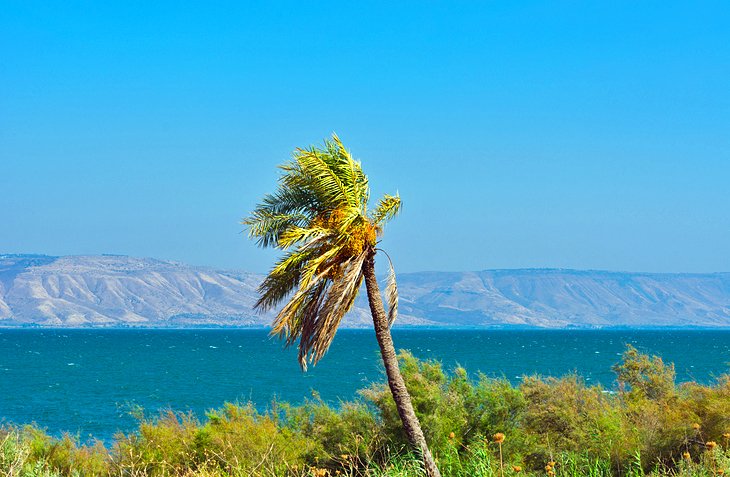
The principal attraction of this little kibbutz is the ancient fishing boatdisplayed here. Discovered in 1986, buried in mud near the edge of the lake, the boat has been dated to between 70 BC and AD 90, meaning that it could have been in use during the time of Jesus.
6 Church of the Multiplication of Loaves and Fishes
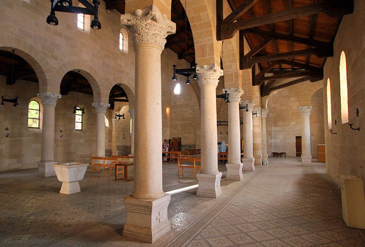
The Church of the Multiplication of Loaves and Fishes is built over the site where tradition states Christ stood during the miracle when he fed the 5,000. Built in 1982, designed by the Cologne architects Anton Goergen and Fritz Baumann, it stands over the site of an earlier Byzantine-era church and has preserved original elements of the older church within the interior. The Byzantine period mosaics on the flooring are the church's most distinctive feature depicting a variety of birds and floral designs. The most interesting mosaics are in the transepts. The artist was evidently familiar with the Nile Delta and has depicted the flora and fauna of that region with flamingos, snakes, herons, ducks, lotus flowers, and reeds. The south transept also shows a Nilometer (a device used for measuring the level of the river). The altar in the sanctuary is built over the stone on which Christ is said to have stood when the miracle was performed. In front is the church's most famous mosaic depicting a basket containing loaves and flanked by two fish.
Location: Tabgha
7 Church of the Primacy of St. Peter
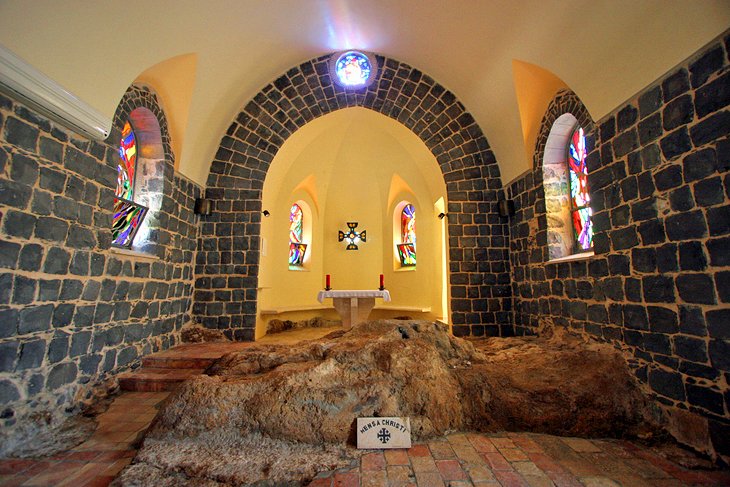
Just 200m farther along the road to Capernaum from the Church of the Multiplication of the Loaves and Fishes, a footpath runs down to the shores of the Sea of Galilee and the Church of the Primacy of St Peter. A chapel built here in the 4th century was destroyed in 1263 and the black basalt present-day church was built by the Franciscans in 1933. The church commemorates the appearance of the risen Christ to his disciples on the shores of the lake when he gave Peter primacy over the church. The rock at the east end of the church is supposed to be the table at which Christ dined with his disciples. On the south side of the church there are rock-cut steps leading down to the lake which were described by the pilgrim Aetheria in about AD 400 as "the steps on which the lord stood".
8 Mount of Beatitudes
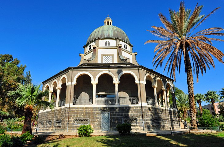
Tradition states that it was here that Jesus delivered his famous Sermon on the Mount. The Roman Catholic Church here (built in the 1930s) holds mass hourly between 8am and 3pm for the pilgrims who travel here. The immaculately kept gardens are a wonderfully tranquil spot to take in the views over the Sea of Galilee, while inside the church itself, there is a lovely stained glass window depicting the Beatitudes.
Location: Tabgha
9 Capernaum
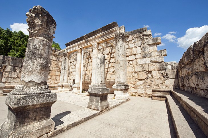
This archaeological site is believed to be the Capernaum of the New Testament where Jesus lived, preached, and gathered the first of his disciples. The beautiful remains of a fourth-century synagogue are the most prominent ruins here, while the modern church on the site is built over the remnants of a Byzantine church and the ruins of the House of St. Peter.
Location: 3 km from Tabgha
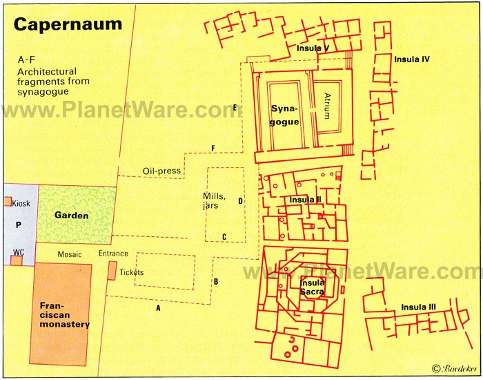
10 Greek Orthodox Church of the Twelve Apostles
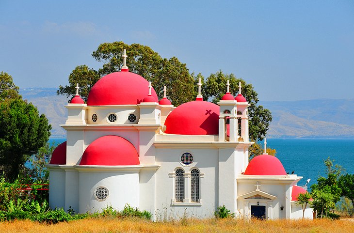
Well worth a visit, this beautiful red-domed church is a major landmark along the Sea of Galilee. It was built in 1925 by the Greek Orthodox Church and has an interior of beautiful icons. The garden here is a shady spot to escape the heat of the midday sun.
11 Bethsaida
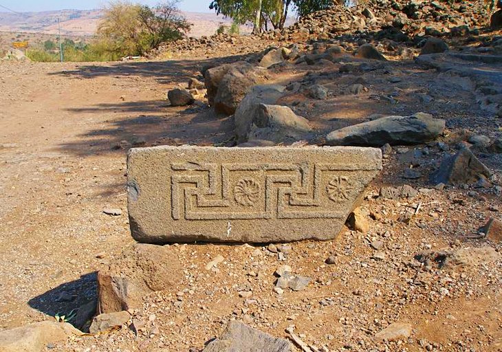
These basalt ruins are believed to be the remnants of the New Testament town of Bethsaida where Jesus performed the miracle of walking on water. As the ruins are mostly only foundations, information boards at strategic points help you interpret the site.
12 Korazim
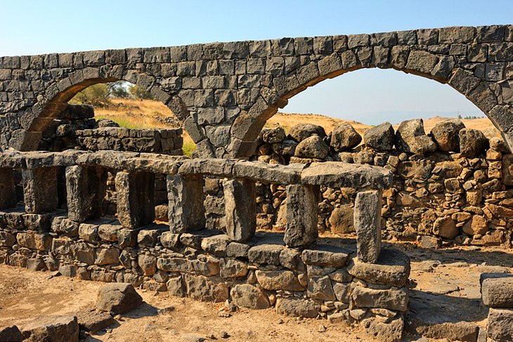
These atmospheric basalt ruins are the remains of another town from the time of Jesus. The main highlight of a visit here is the synagogue, which is home to beautiful carvings with Hellenistic influences on the stones.
13 Yardenit
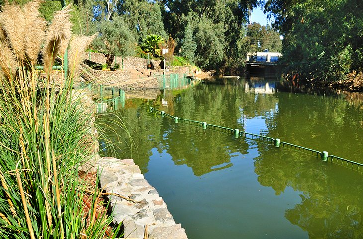
Near the headwaters of the Jordan River, Yardenit is a popular baptism spot for pilgrims looking to dunk themselves in the famous waters of the Jordan. There are wooden platforms built along the river bank to aid visitors who want to immerse themselves.
14 Deganya
The kibbutz of Deganya lies at the point where the Jordan River emerges from the Sea of Galilee. This was the very first kibbutz, founded in 1909 by Russian immigrants, with the original kibbutz now known as Deganya A, and its more recently-founded neighbour as Deganya B. At the main entrance to Deganya A, is a Syrian tank, which in 1948, advanced as far as the kibbutz, but was then knocked out by a Molotov cocktail. Within the territory of the kibbutz is Gordon House (named after Aharon D. Gordon, one of the founders of the kibbutz), a research institute with an archaeological, natural history, and agricultural museum.
Location: 2 km south of Bet Yerah
History
When the Israelites took possession of the Promised Land, the tribes of Naphtali, Zebulun, and Asher settled in Galilee (Joshua 19), where they were later joined by the tribe of Dan (Judges 18). In the eighth century BC, the country was occupied by the Assyrians; later came Babylonians, Persians, and Greeks.
After the Hasmonean conquest in 163 BC, non-Jews lived in the coastal plain and Jews in the upland regions. When the Romans occupied Galilee, it was ruled, along with Judaea, by the Hasmonean ruler Hyrcanus II and then by Herod the Great. Thereafter, in the lifetime of Jesus, it belonged to the tetrarchy of Herod Antipas, who made Tiberias his capital, and then, until 44, to the kingdom of Herod Agrippa. In AD 66, Galilee was a stronghold of the Jewish uprising against the Romans, and after the Bar Kochba rising (AD 135) it replaced Judaea as the center of Jewry, the towns of Bet Shearim, Sepphoris (Zippori), and Tiberias being of particular importance in this connection.
From the seventh century onwards, the Arab population of Galilee increased steadily. The first Jewish settlements of modern times were established at Rosh Pinna (1878) and Metulla, the most northerly village in Israel (1886). In 1948, Galilee became part of the newly founded state of Israel.
1236544444
No comments:
Post a Comment